5x guided tour of STONEHENGE complex, a STONEHENGE webinar (with a lot of registrations) and more than 10 lectures about STONEHENGE given
STONEHENGE reading ppt/pdf NOT AVAILABLE, no requests please
| Direct to the INDEX |
|---|
STONEHENGE
UNESCO WORLD HERITAGE
Treasure of Britain
UNESCO WORLD HERITAGE
Treasure of Britain
On request, "everything" that was told during the STONEHENGE tours, webinar and lectures is summarized in this story!
To understand STONEHENGE, background stories are needed, but always assume that with STONEHENGE there will always be more questions and riddles than answers and explanations....
All often open ends....
The invitation to STONEHENGE webinar and lectures, also more or less the summary of this story, was the following description:
- The Stonehenge complex is perhaps one of the most famous prehistoric sites in Western Europe
and still surrounded by questions and mysteries.
The most striking are of course the famous standing stones, which stand as a special monument in the landscape.
The "Stones inside a henge" forms an integral part with the surrounding archaeological area.
Research has provided more and more insights about this special site in recent years.
How did Stonehenge come about, when, who were the possible builders and what was the function of this archaeological monument.
From 2013 onwards, the entire complex will undergo a thorough revitalisation.
In recent years, many new insights have been gained about the interpretation of the entire complex, including through research on the Orkney Islands, at the Stanton Drew Stone Circle and Waun Mawn.
In a few years, the Stonehenge reconstructed in the 50s become an integral part of a more complete archaeological site.
The nearest Avebury henge is also briefly discussed.
This Dutch English translation is done automatically by Google Translate, so....
Index links stories, there are more to come.... Of course, you can also search for something with CTRL-F ...
- How do you pronounce Stonehenge
- Where does the word Stonehenge come from, probably... i.e. what is the basic principle
- Smaller Bluestones were also used
- Differences between Sarsens and Bluestones
- What is a Henge?? (Organic Growth)
- How many henges are there in England, Scotland, Wales and Northern Ireland?
- What are the dimensions of a henge? Avebury the largest henge?
- How many stone circles are there in Great Britain and what are the dimensions of stone circles, such as those of Stonehenge
- When did stone circles start, such as the one at Stonehenge, with or without a henge
- A henge is round, a stone circle is not always round, a stone circle sometimes points to another stone circle or wood circle.
Like on the Stonehenge site! And what is a Cove / inlet at stone circles?
- Why was the accessibility of both the Stonehenge stone circle and the terrain around it changed around 2013?
- How big is the terrain (Stonehenge site) around the Stonehenge stone circle?
What can you find?
- Can you fly a drone over the Stonehenge site and Stonehenge stone circle?
- What are the Lesser Course and the Stonehenge Course at the Stonehenge site, north of the Stonehenge Stone Circle
- The Barrows / Burial Mounds surrounding the Stonehenge Stone Circle, at the Stonehenge site
- The ceremonial Avenue runs from the River Avon to the Stonehenge stone circle
- Something about Solstices, Equinoxes, Annual Festivals including the Yule / Yule Festival, important in understanding Stonehenge
- The mysterious Durrington Walls and Woodhenge
- The Stanton Drew Stone Circles and Wood Circles ("Woodhenges")
- Heel Stone, Slaughter Stone and Altar Stone are very special Stonehenge stone circle stones
- The (John) Aubrey holes are important for both the creation and alignment of the Stonehenge stone circle. This chapter also discusses the STATION STONES and the Q&R and Y&Z HOLES.
- Stonehenge is part of a larger whole, such as a compact, within walking distance, triple monument on the windswept Scottish Orkney Islands
But we're also going to talk about the North Yorkshire Stonehenge of the North: the Thornborough triple Henges
- Title
- Title
- Title
- Title
- Title
- Title
- Title
- Title
1. How do you pronounce Stonehenge
-
The stress should be on the 2e syllable and therefore NOT on the 1e syllable:
So it is Stone HENGE and not STONE Henge.
So the emphasis is on the concept of HENGE, More about this in this chapter:
| Back to the INDEX |
|---|
2. Where does the word Stonehenge come from, probably... or what is the basic principle
-
The word Stonehenge is said to be a corruption of Stanehinge, translated as Stone hinge.
The bracelet below shows the principle, but with a Stanehinge of course with stones....

Translated to a Stonehenge Trilithon (tristone) a Stone hinge looks like this:
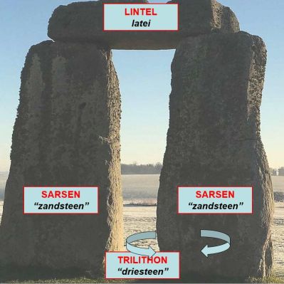
On top lies the Lintel, presses and holds the large heavy Sarsen stones in place. The heavy Sarsens are also bent slightly towards the center of the stone circle, so they are deliberately not perpendicular. The Lintel pushes the whole thing out slightly.
To be able to make a circle of Sarsens, the Sarsens must be able to be rotated a bit when placing and that is in my opinion the most genius about such a Trilithon, how did they do that around 2300 BC???
Try to make a perfect circle yourself with upright long heavy planks to be dug in!
The Lintels (Lintels) were in turn held in place by the Sarsens via a "pin hole" connection and mutual via a "groove tongue" connection and that already around 2300 BC and then in stone...
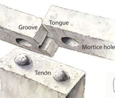
The Sarsens were thus placed in a circle and held by "overlapping" lintels through the pin hole and grooved tongue connections on top of the Sarsens.

And oh yes, don't forget to turn the Sarsens slightly, so that all Sarsens are in a nice circle!
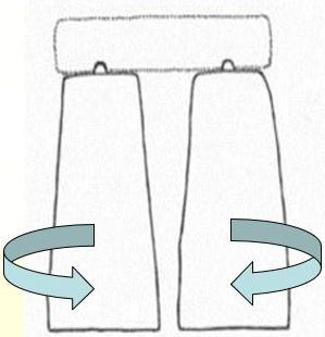
It all seems simple, but around 2300 BC....
The people who designed and executed this had a genius technical insight, for which we can only have admiration and deep respect!
On the photo below you can admire the very beautiful end of a Sarsen on the left, indeed the Sarsen is getting narrower both in height and width, Genius right? And also leans forward slightly, but unfortunately that is not noticeable.
That point on top is the pin for the hole in the Lintel!
Some people think that point on top of the Sarsen is something spiritual, that's allowed, but...
The stone on the right in the photo below, I always give the name "70s scrap, a scrap had a groove on one side of the long side over the entire length (as on this stone) and on the other side over the entire length of the scrap a tongue", joke of course, but to make this groove in stone in 2300 BC... admiration

| Back to the INDEX |
|---|
3. Smaller Bluestones were also used
-
The smaller stones are called Bluestones:

| Back to the INDEX |
|---|
4. Differences between Sarsens and Bluestones
-
Including the place of origin:
- Number of Sarsens: 82
- Description: King-size "sandstones"
- Total height up to 9 meters, of which about 2 meters in the ground
- Weight sometimes about 50,000 kg
- Origin: Marlborough Downs
- Number of Bluestones supplied: 80
- Description: "Blue" granite stones
- Total height up to 2 meters, of which about 0.5 meters in the ground
- Weight sometimes about 3,000 kg
- Origin: Preseli Hills
How did they come to the Stonehenge site and how long did it take etc. we will come back to
| Back to the INDEX |
|---|
5. What is a Henge?? (Organic Growth)
-
A nice compact English definition describes it as follows:
- Circular earthen wall(s) with a diameter of more than 20 meters
- INSIDE the earthen wall (wall) a ditch (ditch) as opposed to a city wall with a ditch OUTSIDE a moat (moat)
- A henge therefore had NO military purpose
- Although Stonehenge ALSO has a barely visible ditch OUTSIDE the earthen wall....
- A henge therefore had NO military purpose
- There are different types of henges: I, II and III: respectively one, two and four opposite passages
A circular banked enclosure with an internal ditch
In Dutch loosely translated as
Circular plain surrounded by an earthen wall with a ditch, accessible through various openings in the earthen wall
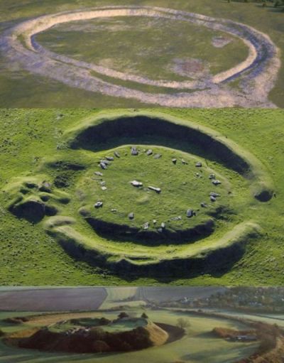
In 1932, Thomas Kendrick came up with the following additional definition of a Henge:
The bottom photo is a very famous henge, OLD SARUM, just west of Stonehenge, also very worthwhile.
Old Sarum is indeed high, by the way this whole area with the name Salisbury Plain is relatively high, always a lot of wind and often rain, Stonehenge is also on the Salisbury Plain, why build something like Stonehenge in such a windy place??
Old Sarum (famous for a number of historical events, but we're not going to talk about that here) was abandoned after a violent storm, north of it, in a more favorable spot, New Sarum was built, which we now know as Salisbury.
What is built within the ditch follows the principle of Organic Growth, what it will look like in the end depends on a lot of factors!
Also for what purpose the henge started, is usually unclear.
And city also grows according to the Organic Growth principle!
In the following image Northern Dutch mounds, possibly also started as a kind of henge?

A mound often focuses on a church.
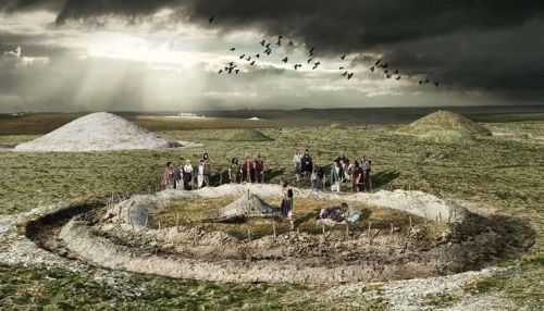
A henge was often a symbol of wealth and power, sometimes religious, a meeting place for gatherings, religious, ceremonial, justice, rituals at happy and sad events etc etc etc
And what was the ditch / ditch for?? Often to put down sacrificial animals and then maybe burn / sacrifice them?? See the following image:
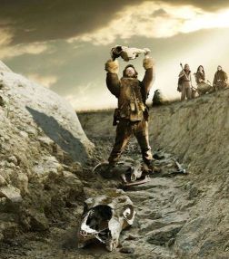
What kind of ditch / ditch dimensions do occur? In the image above ca 1 meter deep, 2 meters wide at the top?
But a ditch / ditch depth of 2 meters, width at the top of 4 meters has also been found!
It must also be realized that the excavation of such a ditch / ditch in say 3000BC or even rather, was quite a job....
How did they do that, with what tool??
With how many people and how long did it take to excavate such a ditch??
And, not unimportant, often such a ditch / ditch is dug out in rocky soils
HOW DID THEY MANAGE THAT???
And last but not least, the sometimes quite high earthen wall of excavated material from the ditch / ditch, was most likely immediately a kind of separation of something that took place (ritual) within the henge, for example in and around the Stonehenge, we will come back to this!!
On the Stonehenge site, north of the Stonehenge Circle, you will find the Stonehenge Course, in short a rectangular henge. (LINK)
| Back to the INDEX |
|---|
6. How many henges are there in England, Scotland, Wales and Northern Ireland?
-
Throughout Great Britain (England, Scotland and Wales, with Northern Ireland as an addition) there are more than 1000, with or without stone circles!
In Scotland there are, in my opinion, over 80 henges, according to the link below, 88 henges in Scotland, of which 6 are excellently described
- By the way, just one of my hobbyhorses....
One of the first things I always tried to convey to Dutch groups is the name of the country, Great Britain; and not England. England is only a part of Great Britain, just as Holland is only a part of the Netherlands.
Calling a Scotsman, Welsman or Northern Irishman an Englishman is therefore not good and is of course not appreciated, just like calling a Frisian or Limburger a Dutchman.
The name of the British Flag is not always correct, the English Flag is really something else.
At the Stonehenge visitor center flies both the British and English flags......

Instead of the long Great Britain you can also call the country UK (United Kingdom) or the UK (United Kingdom) or just call Britain.
In the meantime, were you wondering how many
Then click here
| Back to the INDEX |
|---|
7. What are the dimensions of a henge? Avebury the largest henge?
-
Many henges have a diameter of about 100 meters, very much smaller than 100 meters diameter henges are called Mini-henges, much larger than 100 meters diameter henges are called Superhenges.
For comparison: the Stonehenge
One of the largest henges in Great Britain is located about 35 km north of Stonehenge, AVEBURY.
The AVEBURY henge has a diameter of more than 300 meters and is more than 1 km walk in circumference, own experience too...
The earthen wall is sometimes 5 meters high.
AVEBURY is about 1000 years older than Stonehenge!
AVEBURY originally had more than 600 stones, of which there are now about 100 left, the remaining stones have a height of about 2 to more than 5 meters.
AVEBURY is LESS TOURISTY compared to Stonehenge!
The town of Avebury is partly in the henge, very special, would no longer be given permission for this. According to an urban legend, the part of Avebury within the henge would be haunted....
The Avebury site, see below, (henge with stones) together with the Stonehenge site forms a WORLD HERITAGE SITE, so it's worth going to Avebury as well!
In the bottom image above, this is what Avebury would have looked like!
Avebury had 2 smaller central stone circles and a very large stone circle in terms of dimensions, close to the ditch / ditch! Possibly an imaginary separation of something that took place (ritual) within the henge?
MAIN to Avebury:
How do you get such a beautiful henge circle done, how is that planned, which genius (or group) does this neat circle (just walk past it....) with a diameter of more than 300 meters released and why exactly in this place???
If that had to be done now, days of work just to set out the circle, excavate mechanically (?), assess with aerial photos, still neatly round?? Etc etc.
And then afterwards put all those stones in place: originally more than 600 stones, of which about 100 are now left.
In short, again very great admiration for these Neolithic Superhenge with three stone circles "constructed" between 3500BC and 3000BC (!), Probably hundreds of years have been worked on this, when you realize this, it makes you completely silent.....
| Back to the INDEX |
|---|
8. How many stone circles are there in Britain; and what are the dimensions of stone circles, such as those of Stonehenge
-
So a henge is different from a stone circle, do you want to know how many
- England 316 stone circles, including those of Stonehenge and Avebury.
- Scotland 508 stone circles
- Wales 81 stone circles
- Northern Ireland 156 stone circles
- Channel islands 6 stone circles
- Rest of Ireland 187 stone circles
- Brittany 49 stone circles
Click here
Total there are in Great Britain, Ireland and Brittany (also called Little Britain ) 1303 stone circles:
There is even a stone circle trail from Cornwall via Stonehenge, Avebury and Stanton Drew stone circles, see the following image:
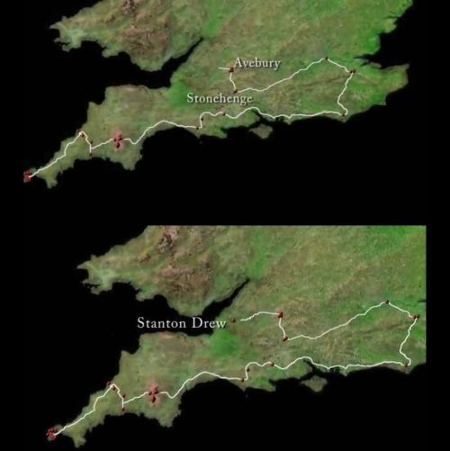
Avebury, diameter over 300 meters: Just click here And look at the bottom image in the composite image, the outer stone circle near the henge has a diameter of more than 300 meters, the 2 smaller stone circles have a diameter of about 100 meters.
The Stanton Drew stone circle (see link below) has a diameter of about 112 meters, the Ring of Brodgar stone circle (we will also come back to that) a diameter of almost 104 meters.
The Stonehenge stone circle has a diameter of about 35 meters.
It has been calculated that the average stone circle, of a total of 1303 stone circles, has only a diameter of about 13 meters. So most stone circles are relatively small compared to, for example, the outer stone circle of Avebury.
According to Alexander Thom a standard size was used when plotting a stone circle, so many times 0.83 meters, he called this a megalithic yard (2.72 feet).
Stonehenge therefore has a diameter of (35 / 0.83) ca 42 megalithic yards
| Back to the INDEX |
|---|
9. When did stone circles, like those of Stonehenge, with or without a henge start?
-
STONE CIRCLES (some call it STONE CIRCLES) wooden poles were often used, (some speak of WOODEN CIRCLES), but they are usually called WOOD CIRCLES. We will see later that wooden poles of sometimes 7 meters length were used, where did they get them from, is immediately the question again....
- Avebury: built between ca 2850BC and 2200BC
- Stanton Drew Stone circle: built between ca 3000 and 2000BC
- Ring of Brodgar: built ca 2500BC
In English, a timber circle was given the name "timber post circles", later with the addition "high density timber post circles", which was of course too long a name and so, just like with Stonehenge (where the name mainly refers to the stone circle), the name WOODHENGE was used.
VERY CONFUSING INDEED
Earlier
Just click here
was told that the word Stonehenge would be a corruption of Stanehinge, translated as Stone hinge.
On the Stonehenge site, an area of about 30 km2, you can also find remnants of a WOODHENGE, we will get to it automatically....
In the image below a Woodhenge as it occurred with the Maya!
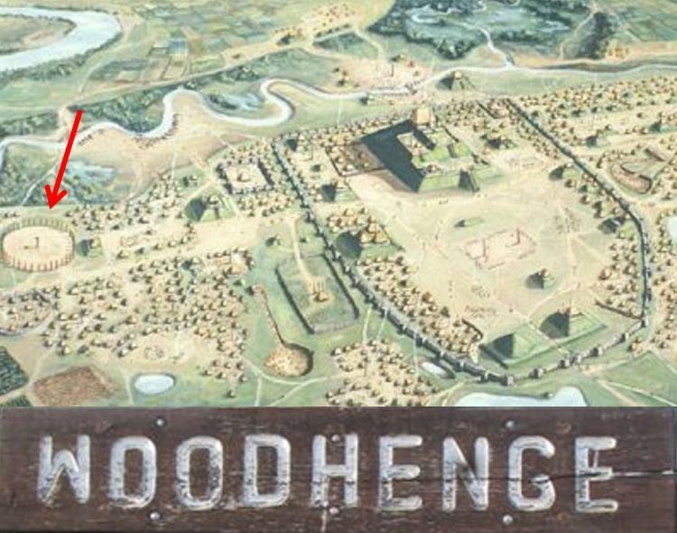
The Native Americans even built Woodhenges around the year 1000, so only 1500 years ago, with a diameter of about 125 meters, for which 48 red painted cedar poles were used.
Why they did this and e.g. also the Mayans, it is assumed to be able to record the different year seasons or the position of the sun! (we will of course come back to this)
Why the wood circles were replaced by stone circles, stones of course last longer, but more importantly, wood is the symbol of finite life and stone the symbol of death and eternity, that's why we also place tombstones and not wood stones!
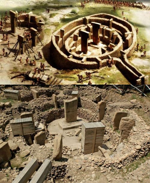
The oldest stone circles are in Anatolia, in Gobekli Tepe and surroundings.
The twenty (!) Gobekli Tepe stone circles date from the year 9000BC and are therefore about 12,000 years old, whether there were wood circles beforehand can no longer be determined at this age. Compared to the Egyptian pyramids, the Gobekli Tepe stone circles were built 5000 years earlier!
In the image below a Gobekli Tepe stone circle, as it should have been (top) and the current situation (bottom):
Stone circles can also be found in South America, (Intiwatan and Calcoence), Armenia; (Karahunge), Iran (Darabgird) as far as Australia; and Japan.
There are also underwater stone circles, once built on land, but disappeared under water in the course of time.
A brilliant example is what was discovered very recently near the Scottish island of Skye, archaeologists from the University of Glasgow have located 20 man-made stone circles there. Diameters 3 - 5 meters!
Conclusion: these now underwater stone circles were made at least 11,000 years ago, so thousands of years older than the Stomehenge stone circle
For more details and a picture click on one of these links, top in English, below a Dutch summary:
A very nice overview of stone circles can be found on this page:
A SMALL SELECTION
If we now limit ourselves to already mentioned and sometimes already discussed British stone circles and end with Stonehenge, these are some years:
If we compare these examples with the Stonehenge stone circle, the Stonehenge stone circle was built later than the above examples, see the image below:
The images above are of course available in all kinds of variants, but this is my favorite....
Start with a henge and then, Organic Growth, a stone circle is created!
For Organic Growth explanation
Just click here
For comparison, we in 2025 will finish something that began in the year 1000 to propose???
Was there a kind of Masterplan behind it, from which there was no deviation?????
Most stone circles have been used sometimes for 2000 years for a ceremony or something similar.
Compared to the Egyptian pyramids, most stone circles were built centuries earlier!
| Back to the INDEX |
|---|
10. A henge is round, a stone circle is not always round, a stone circle sometimes points to another stone circle or wood circle.
Like on the Stonehenge site! And what is a Cove / inlet at stone circles?
-
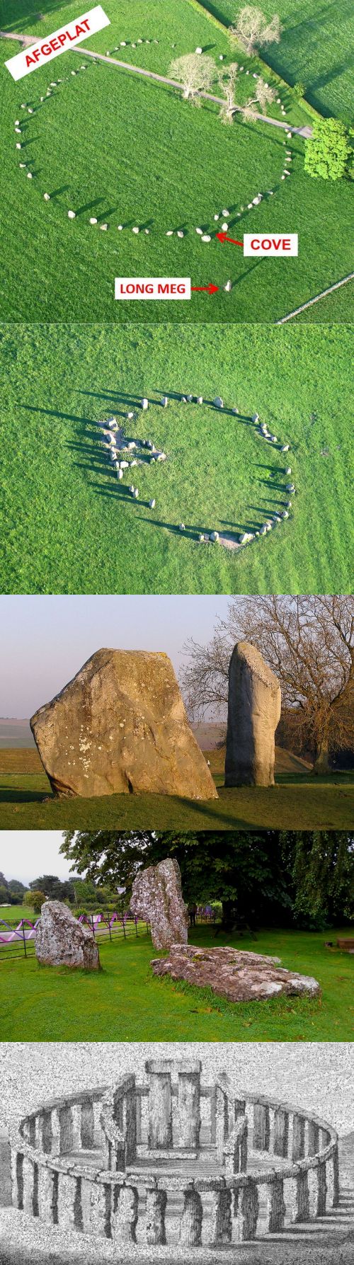
Stone circles do not always have to be round, and are often described as elliptical, egg-shaped, or deliberately flattened in the shape of
eyeballs.
- Flattened stone circle with a reception stone at the bottom right with the hall / Cove above it, the whole has the nice name Long Meg and Her Daughters in Cumbria (Lake District) and are part of a large stone circle complex northeast of Penrith. The third in size after the Avebury and Stanton Drew stone circles respectively.
- An obvious Cove, name stone circle???
- Avebury Cove
- Stanton Drew Cove
- If the Stonehenge stone circle would have had a Cove, maybe it would have looked like this??
Stone circles often "look" at each other, when you go out, "you walk right in at another stone circle", on the Stonehenge site this is also the case, the opening of the Woodhenge is aimed at the opening of the Stonehenge stone circle, we will come back to this.
Stone circles are or were often provided with a Cove, literally an inlet, but I have always used (for the Dutch group) the Dutch description "halletje". In the Netherlands you usually step through the front door into a hall, usually described in English as Reception Room.
In a Cove people were received or the ceremony began???
In the image below some examples of a flattened stone circle and a Cove, from bottom to top:
| Back to the INDEX |
|---|
11. Why was the accessibility of both the Stonehenge stone circle and the terrain around it changed around 2013?
-
Until well into the 80s, if you drove west via the A303, you could turn right to the A344 just before Stonehenge and then park near the Stonehenge stone circle and in my memory you were also allowed to walk through the Stonehenge stone circle. Well those days are rightly over!
There was only a small parking lot, so there was also parking on the roadside!
With a large group in 2010 you had to walk through a narrow narrow tunnel under the A344, people on the way back had to go through it at the same time, A claustrophobic experience, BBRR!
Near the Stonehenge stone circle you can still find a small piece of that scary narrow tunnel, of course worth a photo for the elderly, with stories:
"Do you remember when we walked there in that crowd of people??"
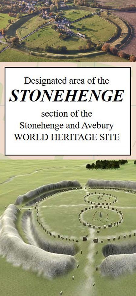
Anyway, that's all over, because for several reasons everything was drastically changed to the current situation. The result was more peace and respect for something that was once built EN the surrounding terrain (the Stonehenge site / terrain / landscape) became more accessible.
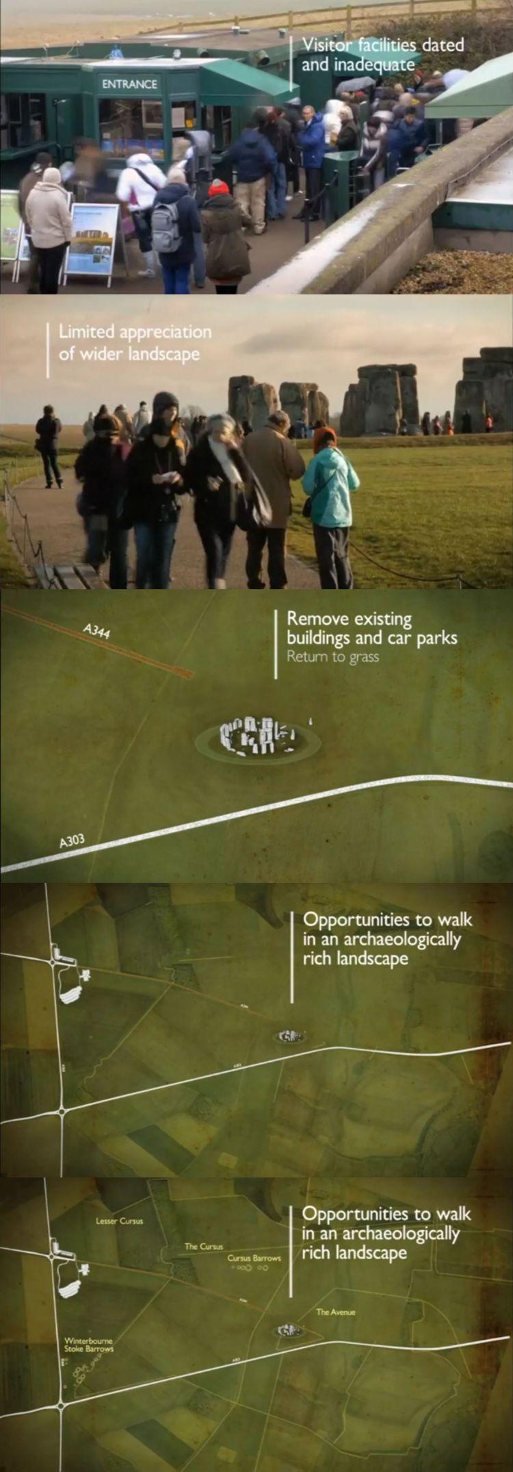
It was summarized as follows, see image above, from top to bottom:
Visitor facilities dated and inadequate
Long queues for the single cash registers, turnstile gates that regularly got stuck
Limited appreciation of wider landscape
It was "just" about taking a picture of the Stonehenge stone circle and then quickly back to the car / bus!
What has changed?
Remove existing buildings and car parks.
Return to grass.
A344 so disappeared as a main road, remnants narrowed, is now used by the shuttle buses, what is not necessary, has just been removed!
Opportunities to walk in an archaeologically rich landscape
In the bottom image (of the image above) what can be seen globally, including on the left the current visitor center with large parking lot.
In the next chapter (LINK) clearer images)
There are now better functioning cash registers, more than enough toilets, a fantastic exhibition space and of course a restaurant annex shop. It was hardly there before 2013. And of course, it is recommended to buy your ticket to get close to the Stonehenge stone circle online. Really saves a few lines!
There are shuttle buses from the visitor center to the Stonehenge stone circle and back, only on presentation of your ticket of course.
To the left of the visitor center you can walk onto the site for free (Stonehenge site), you come close to the Stonehenge stone circle, only then do you have to show your ticket to get close to it!
Finally, make no mistake about the area / distances of the Stonehenge site / terrain / landscape!
The Stonehenge site has an area of about 30 km2 (so more than 4000 football fields) and more than 400 prehistoric monuments, including the Stonehenge stone circle.
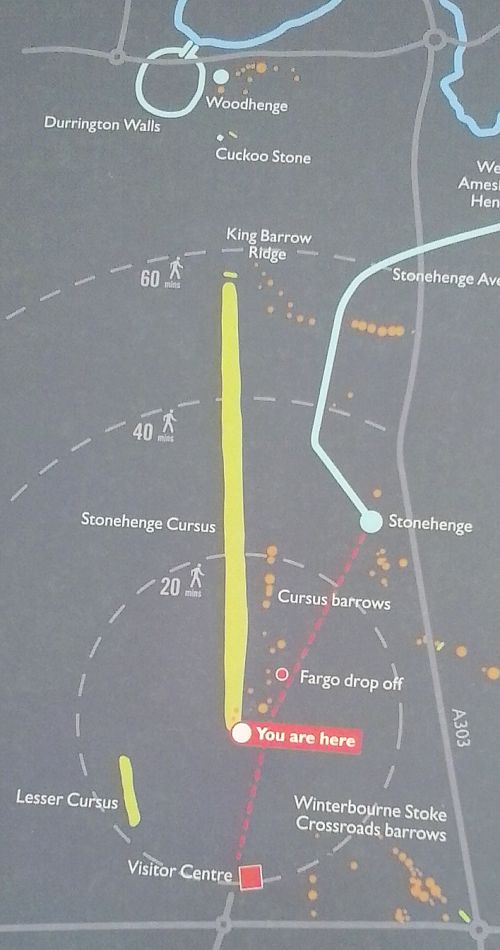
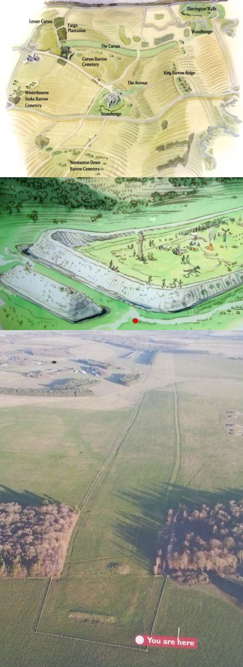
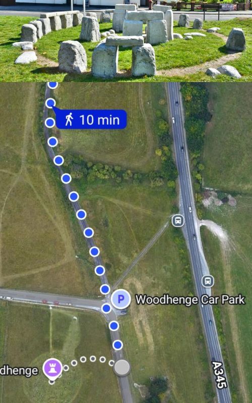
According to the above image, made about 200 meters to the left of the visitor center in the direction of the Stonehenge stone circle, it is about a 90-minute walk over grassland v.v. to the Durrington Walls / Woodhenge and then you also have to walk back, or walk south, (to the right in this image) same distance or, even better, walk to the Stonehenge stone circle, from the Durrington Walls / Woodhenge this is about a 60 minute walk and show your ticket there, and then take the shuttle bus back to the visitor center.
From the YOU ARE HERE walk directly to the Stonehenge stone circle in the picture, will take you about 30 minutes! At some point you really have to show your ticket or walk back.
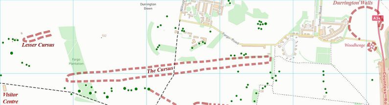
That yellow stripe on the picture is the length of the Stonehenge Course, and below that on the left the shorter yellow stripe is the Lesser Course, we will also come back to this of course, just like on the Durrington Walls / Woodhenge and the many Barrows etc. (LINK)
The red line along the Fargo drop off is the route of the shuttle bus over the discontinued remains of the A344 and ends at the Stonehenge stone circle and indeed the dot of the Stonehenge stone circle is only part of the huge Stonehenge site, now more accessible than before 2013.
A separate chapter has been made about the Stonehenge site and flying a stone circle with a drone, (LINK), in short DON'T, FORBIDDEN!
In the next chapter (LINK) we will go deeper into what can be seen during the walk on the Stonehenge site, of course with a map, which you can open via a link.
| Back to the INDEX |
|---|
12. How big is the terrain (Stonehenge site) around the Stonehenge stone circle?
What can you find?
-
With the help of this link you can view the entire Stonehenge site:
- What are the Lesser Course and the Stonehenge Course at the Stonehenge site, north of the Stonehenge stone circle
- The Barrows / Burial Mounds around the Stonehenge Stone Circle, at the Stonehenge site
- The ceremonial Avenue runs from the River Avon to the Stonehenge Stone Circle
- The mysterious Durrington Walls and Woodhenge
In my lectures I have always asked, where is the Stonehenge stone circle?
Indeed a bit of searching maybe, very small compared to the rest, BUT nice and central.
To help people in the room, I then had Powerpoint draw a RED circle around the Stonehenge stone circle, indeed, the Stonehenge stone circle is very small in area compared to the rest of the Stonehenge site!
But the Stonehenge stone circle is the most important cultural-historical monument on the Stonehenge site
Have measured the map once and came to the following dimensions: ca 5.5 at 5.5 km2, so it is consistent with the following quote from the previous chapter: (LINK)
-
The Stonehenge site has an area of approx 30 km2 (so more than 4000 football fields) and more than 400 prehistoric monuments, w.o. the Stonehenge stone circle.
According to the above image, made about 200 meters to the left of the visitor center in the direction of the Stonehenge stone circle, it is about a 90-minute walk over grassland v.v. to the Durrington Walls / Woodhenge and then you also have to walk back, or walk south, (to the right in this image) same distance or, even better, walk to the Stonehenge stone circle, from the Durrington Walls / Woodhenge this is about a 60-minute walk and show your ticket there, and then take the shuttle bus back to the visitor center.
From the YOU ARE HERE on the image directly to the Stonehenge stone circle, it will take you about 30 minutes! At some point you really have to show your ticket or walk back.
That yellow stripe on the picture is the length of the Stonehenge Course, and below that on the left the shorter yellow stripe is the Lesser Course, we will also come back to that of course, just like on the Durrington Walls / Woodhenge and the many Barrows etc.
The red line along the Fargo drop off is the route of the shuttle bus over the discontinued remains of the A344 and ends at the Stonehenge stone circle and indeed the dot of the Stonehenge stone circle is only part of the huge Stonehenge site, now more accessible than before 2013.
Over the Stonehenge site and stone circle flying with a drone, a separate chapter has been made, (LINK), in short DON'T, FORBIDDEN!
In this chapter we will take a closer look at what can be seen during the walk on the Stonehenge site.
What can we do on the Stonehenge site:
In separate chapters they are then discussed separately
Of course we will also continue with the origin, construction, history etc etc of the Stonehenge stone circle!
| Back to the INDEX |
|---|
13. Can you fly a drone over the Stonehenge site and Stonehenge stone circle?
-
Without written permission from English Heritage, NOT may be flown over the Stonehenge site!
flying over the Stonehenge stone circle is FORBIDDEN.
The Stonehenge site can be visited FREE, if you want to get close to the Stonehenge stone circle, you have to pay for it and so attempts are made to fly over the Stonehenge stone circle from the freely accessible Stonehenge site...
DON'T please very disturbing!
For more info
| Back to the INDEX |
|---|
14. What are the Lesser Course and the Stonehenge Course at the Stonehenge site, north of the Stonehenge Stone Circle
-
PLEASE NOTE: COURSE MEANS CURSUS, Google translation....
- An overview
- As it could have been
- The current situation
Quote from the chapter What is a Henge?? (LINK):
- On the Stonehenge site, north of the Stonehenge stone circle, you will find the Stonehenge Course, In short, a rectangular henge.
In Dutch you can best describe the term Course as Structure or Earthwork.
In Great Britain there are about 500 (!) courses, only in the Stonehenge Course you can still recognize something of the earthen wall with ditch, But don't imagine too much of that, it's not all really clear anymore, after walking past it for a few hundred meters, most people drop out.
Course comes from the Latin for 'racetrack'. It used to be believed to be Roman racetracks!
The Stonehenge Course is dated between 3630 and 3375 BC, so several hundreds of years before the construction of the Stonehenge Stone Circle!
The Stonehenge Course is approx 3 kilometres long and approx 100 - 150 metres wide.
The Stonehenge Course is more or less aligned east-west and is focused on the sunrise on the spring and autumn equinoxes, what are equinoxes?
It is discussed in this chapter:
The ditches of the Stonehenge Course (ditches henge: see (LINK) ) are not the same everywhere in width and depth. The width varies between 2.75 meters and 1.8 meters, the depth between 0.75 meters and 2 meters.
Of the Lesser (Small) Course there is little left, In WWII it seems to have been ploughed up, and so hardly anything to discover is my experience.
The Lesser (Small) Course is about 400 meters long and 60 meters wide, facing west-southwest and east-northeast.
During excavations at the Lesser Cursus pickaxes of red deer antlers were discovered, dated to about 3000 BC.
What was the purpose of Courses? No one knows exactly, but it could be, it is assumed, that it is a ceremony. le place was to walk in the daily track of the sun, so from East to West.
Finally some images: this one below with yellow "Stonehenge Course" stripe, comes from this chapter, among others: (LINK)

Below, from top to bottom:
| Back to the INDEX |
|---|
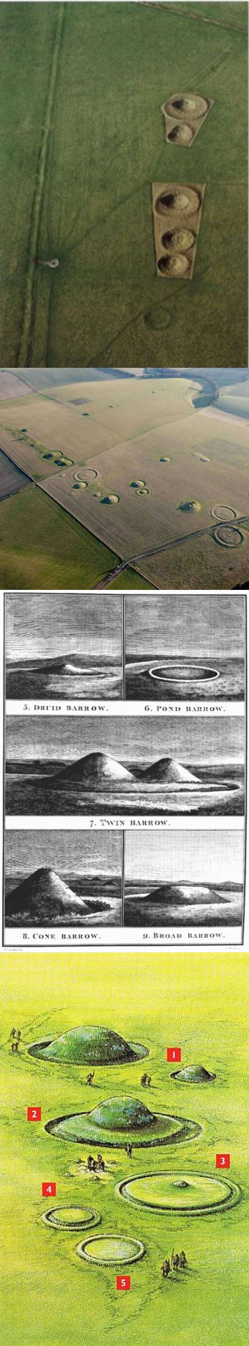
15. The Barrows / Burial Mounds surrounding the Stonehenge Stone Circle, at the Stonehenge site
-
The Stonehenge Barrows, as they are usually called, are sometimes different in shape and sometimes empty, compared to Barrows elsewhere in Great Britain.
- Winterbourne Stoke Barrow Cemetery, on the right side of the road to the Stonehenge stone circle
- Normanton Down Barrow Cemetery, on the other side of the A303
- Course Barrow Cemetery
- Normanton Down Barrow Cemetery
- 2 examples of Stonehenge Barrow forms, numbers #2 and #4 are also called Cup and Saucer Barrow...
The Stonehenge Barrows were sometimes used several times, sometimes everything was cleared first and sometimes not. Why?
The Stonehenge Barrows/Burial Mounds are also usually grouped together. Why?
It is suspected that being buried somewhere on the Stonehenge site in the Stonehenge Barrows / Burial Mounds was a very special privilege, or the distance to the Stonehenge stone circle was also important?
In total there are about 400 Barrows / Burial Mounds somewhere on the Stonehenge site!
Graves have also been found nearby, around the Stonehenge stone circle, in the famous Aubrey Holes, we will of course come back to that.
The Stonehenge Barrows sometimes differ in shape from Barrows / Burial mounds elsewhere in Great Britain.
A few well-known names of Stonehenge Barrow / Burial mound groups at the Stonehenge site are, see also the maps in the following chapters:
How big is the area (Stonehenge site) around the Stonehenge stone circle?
What are the Lesser Course and the Stonehenge Course at the Stonehenge site, north of the Stonehenge stone circle
What are the Lesser Course and the Stonehenge Course at the Stonehenge site, north of the Stonehenge stone circle
In the last mentioned chapter about the Lesser Course and the Stonehenge Course you can see in the last image, to the right of the Stonehenge Course, above the trees, the
Course Barrow Cemetery
discover!
In the images below an enlargement of the Course Barrow Cemetery.
But also these Stonehenge Barrow / Burial Mound groups on the Stonehenge site are worth a visit:
All these mentioned Stonehenge Barrow/Burial Mound groups I have ever visited, Don't expect too much of it, of course it's not really spectacular, but you do come to your senses, there is an enormous peace of mind, to be there and muse about what has happened here and then see all those people from a distance at the Stonehenge stone circle.
In short, I highly recommend to look for the Stonehenge Barrow / Burial Mound groups on the Stonehenge site!
Of course also some images with explanation:
A beautiful reconstruction!
This image is from the chapter
- Quote:
And what was the ditch / ditch for?? Often to put down sacrificial animals and then maybe burn / sacrifice them??
Whether that also happened at the Stonehenge Barrows????
From top to bottom:
| Back to the INDEX |
|---|
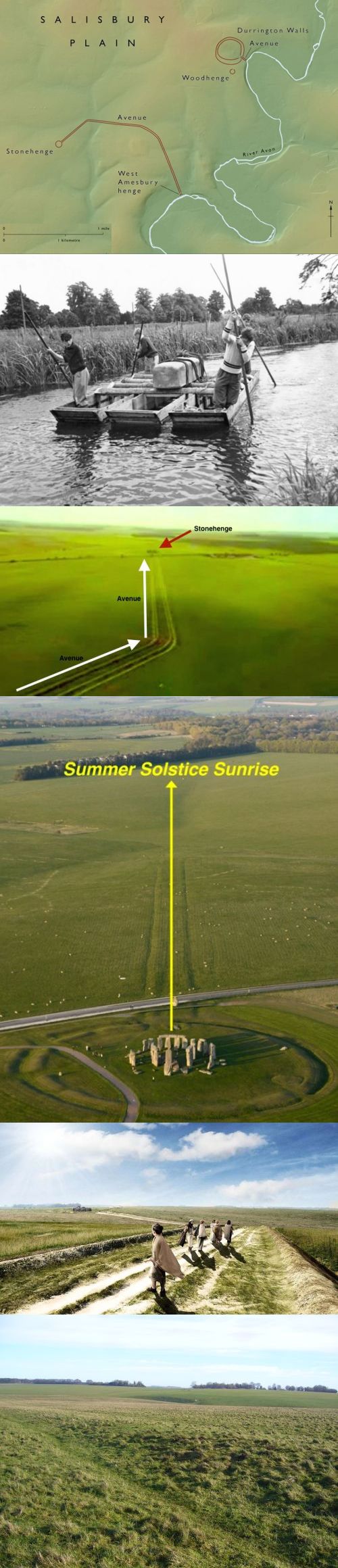
16. The ceremonial Avenue runs from the River Avon to the Stonehenge stone circle
-
It is advised to read this chapter first:
- There are two avenues, one to the Stonehenge Stone Circle (length about 3 km) and, on the right, one to the Durrington Walls. Both Avenues come from the River Avon
- In the 60's it was shown that heavy Stonehenge stones can also be transported over the water of the River Avon or it happened that way, I never read anything about it again...
- The bend in the Avenue towards the Stonehenge stone circle is called BOTTOM, the periglacial stripes are clearly visible, for more explanation, see above
- The Stonehenge stone circle was aligned in line with the Avenue periglacial stripes
- On the way via the Avenue to the Stonehenge stone circle, again clearly visible the periglacial stripes
- A barely visible Avenue, if you know it, you will see it. From the Stonehenge stone circle a bit more visible, indicated by an arrow on the ground, on the left side of the Stonehenge stone circle, there is always someone pointing at it...
To get your orientation, look at the fourth image, with the yellow text Summer Solstice Sunrise, stand at the beginning of the yellow arrow near the Stonehenge stone circle and then try to discover the Avenue!
The ceremonial Avenue runs from the River Avon to the Stonehenge stone circle
On the grounds of the Stonehenge site there are even TWO Avenues (NL: Lanen): one to the Stonehenge stone circle (length about 3 km) and one to the Durrington Walls. (Link see below)
Both Avenues come from the River Avon.
Of course they were ceremonial roads on the way to the Stonehenge stone circle and the Durrington Walls:
The Avenue may also have been used to transport something to the Stonehenge stone circle and the Durrington Walls.
In 2009 a ring of pits was discovered near the River Avon containing some stone remains, but it later turned out to have nothing to do with the Stonehenge stone circle Bluestones, the idea was that near the River Avon the Bluestones were temporarily stored / placed to be taken to the Stonehenge stone circle later.
What are Bluestones, see these stories:
The most important function of the Avenue, it was discovered, is that the direction of the Avenue coincides exactly with the sunrise of the Summer Solstice.
The presence of ridges and gullies (periglacial stripes) that happen to be (?) were in line with the direction of the Summer Solstice, was possibly revered and later used to align the Stonehenge stone circle!
The Avenue AROUND the ridges and gullies (periglacial stripes) to the Stonehenge stone circle is even said to have been deliberately constructed, somewhere between 2600 - 1700 BC. And AFTER THAT the Stonehenge stone circle was built, the much older ridges and gullies (periglacial stripes) were of course available all year round to while the Summer Solstice is only short, of course.
In short, A BRILLIANT SOLUTION to build and align the Stonehenge stone circle
Below are 6 images with explanation, from top to bottom:
| Back to the INDEX |
|---|
17. Something about Solstices, Equinoxes, Annual Festivals including the Yule / Yule Festival, important in understanding Stonehenge
-
On the internet you can of course find much more information about Solstices, Equinoxes, Annual Festivals including the Yule / Yule Festival, so in this chapter a summary.
- Imbolc (around 2 February): also called Ploughing and Sowing Festival, the earth is made fertile again.
- Ostara (around 21 March): feast of the New Life, also called Spring Festival, the first eggs appear, (Easter fires), Spring Equinox
- Beltane (around May 1): fertility feast
- Midsummer Litha (June 21): solar power maximum, after that the days get shorter, Summer Solstice
- Lughnasa / Lammas (around August 2): feast of the grain harvest
- Mabon (around September 21): another harvest festival, this time around the picking of fruits, Autumn Equinox
- Samhain (November 1): start of darker times, days are getting shorter (Haloween)
- Yule (around December 21): Midwinter festival, start of the new year, the sun slowly returns, the wheel of the year is started again, Winter Solstice, MOST IMPORTANT ANNUAL FESTIVAL
- JOEL (Dutch) / Yule (English) also literally means Midwinter feast, in many languages it is still synonymous with Christmas and the period around it!
- In Swedish and Danish, for example, Christmas is still (sometimes?) Yul.
- In English, in some regions of England and Scotland, including some Orkney and Shetland Islands, Christmas and especially the accompanying Christmas season are still called Yule.
- In the eastern part of northern Germany, the word Jul is also often used for the entire Christmas season!
- The 12 transitional nights around the New Year, the Sun will shine longer again, in the fight between Summer and Winter, Summer will fortunately be the victor again
- Commemorating deceased ancestors with cult festivals
- New fires are lit, the old fires are extinguished
At a Solstice, (Latin: Solstitium) we have a Summer Solstice and a Winter Solstice, with respectively the longest and shortest day in combination with respectively the shortest and the longest night, so on or around June 21 and on or around December 21.
With an Equinox, the days and nights are the same length, and so we have a Spring Equinox (on or around March 21, the beginning of spring) and an Autumn Equinox (on or around September 23, the beginning of autumn).
Our ancestors, such as the Germans, also knew these special days.
The designers of the Stonehenge stone circle have consciously used their knowledge about solstices in particular!
In summary, the Stonehenge stone circle was "aligned" on or around the Summer Solstice, but the largest festivities in the following years were celebrated NOT on or around the Summer Solstice, BUT on or around the Winter Solstice, about which of course much more later and in subsequent chapters!
For centuries, the Germanic people and the builders of the Stonehenge stone circle and many other cultures, even organized parties every 2 months, which we still know today!
The 2 monthly festivals are called the JAARFEESTEN / every 2 months celebrations, as can be seen in the circle diagram below:
KERSTFEEST = CHRISTMAS
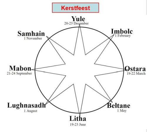
So there are 8 ANNUAL FEASTS :
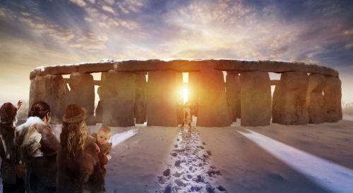
The Winter Solstice has indeed become our Christmas, the lights in the Christmas tree symbolize the stars in the sky, the peak symbolizes the pole star, the garlands the milky way, according to tradition!
How did Christmas originate instead of the Yule feast, In summary:
On December 25, the Romans celebrated the Winter Solstice, the Dies Natalis Solis Invicti. The God Mithras, also known as Sol Invictus, or the Invincible Sun, was worshipped. Celebrating the birthday of the Invincible Sun was a popular custom in Rome.
In the 4e century, Pope Liberius therefore established the birthday of Christ on the same December 25 as a replacement for the Yule feast, so the choice for December 25 is not based on Biblical sources. The choice for this day can also be seen as a concession to the Romans to be converted.
Maybe some fun facts:
And then the Stonehenge stone circle, it will be clear that here too the Yule festival was the most important annual festival, the Stonehenge stone circle was even erected to celebrate the Yule festival together from the Durrington Walls and via the Avenue: see these 2 chapters:
The mysterious Durrington Walls and Woodhenge
The ceremonial Avenue runs from the River Avon to the Stonehenge stone circle
The ceremonial Avenue runs from the River Avon to the Stonehenge stone circle
Finally, an often-used image, I think it was once in the Stonehenge Visitor Center, the Yule party at the Stonehenge stone circle, we will come back to that more often. The most important thing can be discovered on the image below in which time of year this Yule festival took place, INDEED DURING A SNOW PERIOD, on or around December 21!!
In the Durrington Walls story (see link above) there are more arguments why the Winter Solstice was much more important than the Summer Solstice. And fortunately, BBC News also pays attention to the celebration of the Winter Solstice at the Stonehenge stone circle and it is usually said that the celebrated Winter Solstice (Yule) was celebrated much more exuberantly than the Summer Solstice (Litha).
A participant of the Winter Solstice talked about the celebration, also now, of the Yule Festival.
Of course the chance of better weather on the higher windy Salisbury Plains at the Stonehenge stone circle at the Summer Solstice (Litha) is higher than at the Winter Solstice (Yule), but whether everyone who participates in the Summer Solstice (Litha) realizes that the Winter Solstice (Yule) at the Stonehenge stone circle is much more important? After reading this chapter and other chapters on this web page, hopefully so!!
Of course I once experienced a Winter Solstice (Yule) at the Stonehenge stone circle, the weather was not exactly nice, moreover there were fighter jets flying over, because Salisbury Plains is also used as a military training ground, we will also come back to that.
| Back to the INDEX |
|---|
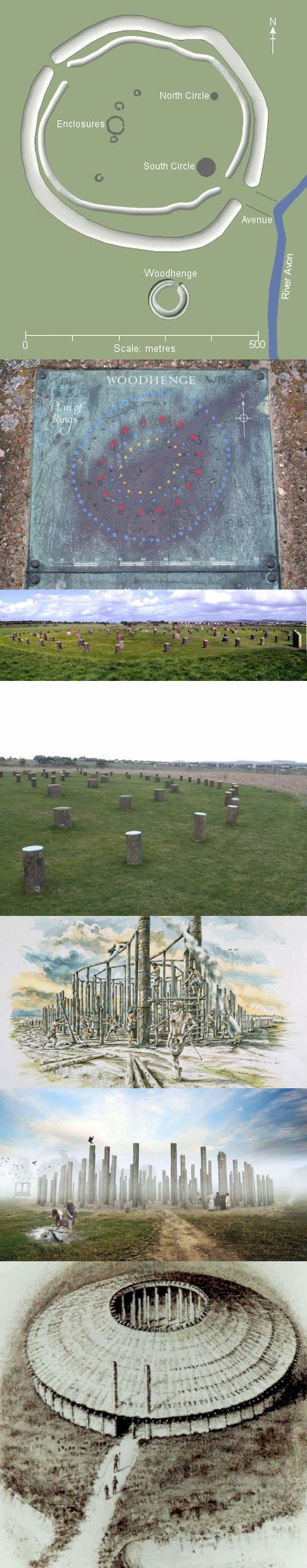
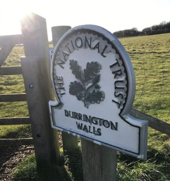
18. The mysterious Durrington Walls and Woodhenge
-
It is advised to read this chapter first:
- Dimensions, at the top of Durington Walls including the famous SOUTH CIRCLE, aligned in the same way in terms of solstices as the Avenue (link see below) to the Stonehenge stone circle, and thus also the alignment of the Stonehenge stone circle, but also that of Stanton Drew! (link see below) At the bottom Woodhenge
- The Woodhenge explanatory sign
- This is what you see, on the right the Woodhenge explanatory sign
- You can rest on it for a while, they are durable stone poles, not wooden
- This is how it could have been
- This is how it could have been
- This is how it could have been
The mysterious Durrington Walls and Woodhenge
We start with some maps and text from this story:
The Stonehenge site has an area of about 30 km2 (so more than 4000 football fields) and more than 400 prehistoric monuments, including the Stonehenge stone circle.
Top right Durrington Walls and Woodhenge
Top Durrington Walls and Woodhenge
According to the above image, made about 200 meters to the left of the visitor center in the direction of the Stonehenge stone circle, it is about a 90-minute walk over grassland v.v. to the Durrington Walls / Woodhenge and then you also have to walk back, or walk south, (to the right in this image) same distance or, even better, walk to the Stonehenge stone circle, from the Durrington Walls / Woodhenge this is about a 60 minute walk and show your ticket there, and then take the shuttle bus back to the visitor center.
From "Madurodam" it is about a 10 - 15 min walk south to the Durrington Walls and Woodhenge.
- If all goes well, you can walk to the Durrington Walls via the Avenue, of course you can also walk from the Durrington Walls...
The 2 Avenues of the Stonehenge site are discussed here:
Below images of resp. "Madurodam" and the (including walk)route to the Woodhenge parking
On the way to the Woodhenge parking you will (about 5 minutes walk from "Madurodam") automatically pass the Durrington Walls
We'll start with the story about the Woodhenge, a bit easier than the one about the Durrington Walls
First of all, the concept of WoodHENGE is not correct, the concept of WoodCIRCLE is better...
For more details on this confusing choice of words, see:
In summary:
Linguistically you can still disagree about the term Stonehenge, there is indeed a Stone circle within a Henge, but the whole site is also called Stonehenge and that sometimes causes confusion, I know from experience, which is why I have always talked about the Stonehenge stone circle and the Stonehenge site etc.
Since the Woodhenge NOT is in a Henge state, the concept of Woodhenge is therefore very confusing, I think! But it is no different, so established.... in short, so be it!
- And what is a Henge, is explained in this story:
- Explanation from top to bottom:
The Woodhenge and parts of Durrington Walls are made of wood, symbolizes life.
The Stonehenge stone circle is made of stone, symbolizes the death.
So there was a procession from the Avenues of the living to the dead!
So we will continue HERE with the Durrington Walls, but first these images with conclusion about the key question of the why of a.o. al die Woodhenge wooden poles, quote from this story:
- The high density wooden (timber) post monument top view
- The high density wooden (timber) post monument side view
- Around the Great Circle a large ditch of about 7 meters wide with a diameter of about 135 meters, surrounded by probably 1 or 2 earthen walls, in short a very impressive henge
- Maybe there was a roof on it???
- Overview
- On the North-East side of the Great Circle an approx. 50 meter wide entrance
- On the North-East side of the Great Circle an approx. 50 meter wide entrance with 'square-in-circle' or 'four-poster' construction, enlarged
- And finally some images with explanation:
- After that of course the key question:
WHY ALL THOSE GIGANTIC WOODEN POLES
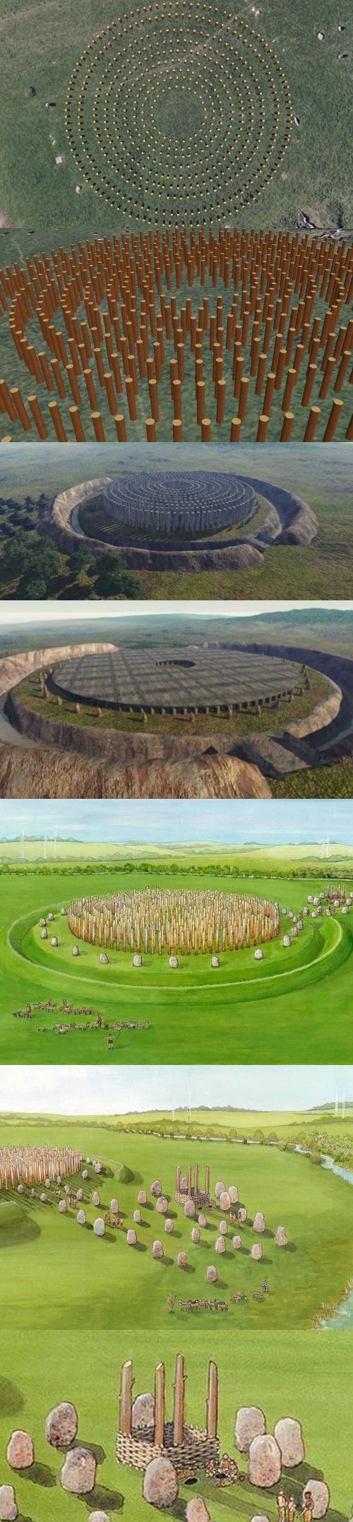
Last but not least, the key question is of course:
WHY ALL THOSE GIGANTIC WOODEN POLES
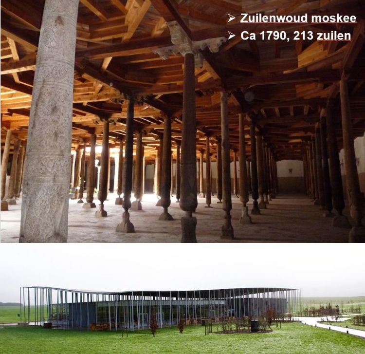
My answer has always been, with an example from Uzbekistan, where I once went as a tour guide with a large group, see the top image below:
The local guide in Uzbekistan told me that each pole was maintained by a family / clan etc, the family / clan came to their pole to celebrate happy and sad events together as a family / clan or to commemorate it. In short, it was a place for meetings with the family / clan etc, just like we do, for example, at a funeral / cremation etc. or afterwards at a get-together, whether or not together, at a tombstone, for example.
The guide in Uzbekistan also said that no deceased were buried under or near the poles and that is also not the case with high density wooden (timber) post monuments
In short, the poles symbolize individual/group meeting places, and the architect has also incorporated this in the design of the visitor center of the Stonehenge site, See the bottom image below. A few times I have seen group photos taken at the poles at the visitor center!
From here on it's about the Durrington Walls:
Durrington Walls was/is a very large Henge, with a Wall and a Ditch!
For more info about the concept HENGE:
Summarized the dimensions and some years of Durrington Walls:
And of course a few things are explained in the image below!
Henge diameter Durrington Walls about 500 meters and so Durrington Walls is a Superhenge!
< br> Durrington Walls Ditch (ditch): 5.5 meters deep, about 7 meters bottom width, up to about 18 meters at the top of the ditch.
The Durrington Walls (earthen wall) sometimes had a width of 30 meters!
In summary, Durrington Walls is comparable to the AVEBURY henge.
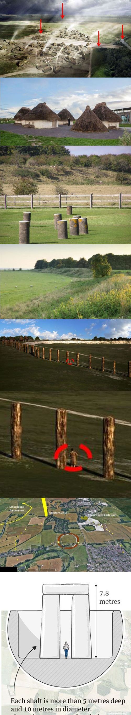
Durrington Walls originated from about 2600BC, somewhere between 2800BC and 2100BC, used for about 500 years, from about 2600BC started with the construction of the henge, which, it is estimated, hundreds / thousands of people must have been needed.
Of the once undoubtedly imposing Durrington Walls there is now little more than just a "basin" as it is called, or a large shallow pit that is still visible.
It has been suggested that originally there were perhaps 1000 Neolithic houses, with perhaps 4000 inhabitants, initially without an earthen wall. The earthen wall was later sometimes built over some Neolithic houses!
The inhabitants of these Neolithic houses have been involved in the construction of the Stonehenge stone circle.
Behind the visitor center are a number of historically correct Neolithic houses, as they were on the Orkney Islands and in Durrington Walls.
Later the earthen wall was provided with about 7 meter high wooden poles, WHY??
And again the question where were all those wooden posts (timber posts) taken from and what a job to put them all upright at regular distances! WHY??
Initially it was thought that there were stones instead of wooden poles, but that turned out to be incorrect.
The South Circle in the Durrington Walls was aligned in the same way as the Avenue, the Stonehenge stone circle and Stanton Drew. All heading southeast in the direction of the sunrise during the Yule festival, or the winter solstice.
A little earlier in this story, with the Woodhenge images, there is this explanation in image 1:
- Durington Walls including the famous SOUTH CIRCLE, aligned in the same way in terms of solstices as the Avenue to the Stonehenge stone circle, and so also the alignment of the Stonehenge stone circle, but also that of Stanton Drew!
During the Yule feast sometimes 4000 people were present, during excavations bones etc of sacrificial animals were found of ca 7 - 8 months old, So born in the spring, a month before the summer solstice around June 20, but the summer solstice was hardly celebrated.
One of the arguments that the winter solstice was much more important than the summer solstice are the excavated bones of sacrificial animals of about 7 - 8 months old during the winter solstice. If the bones had been about 1 month old, the sacrificial animals would have been sacrificed during the summer solstice!
For an excellent English Heritage article about the excavated bones etc. during the winter solstice, click on this link:
For more background information on this site by Aad Engelfriet about Solstices, Equinoxes, Annual Festivals including the Yule / Yule Festival:
And last but not least, why is the addition mysterious Durrington Walls used in the title of this chapter?
Around 2020, in a circle of about 2 km, far outside the Durrington Walls, discovered wells in which a complete Trilithon would fit, again the question WHY??
So far about 20 of these gigantic wells have been discovered! It is now also called the largest prehistoric monument in Great Britain.
Explanation from top to bottom:
- Durrington Walls reconstruction, with arrows from left to right: Woodhenge of South Circle (?), Wall, Durrington Walls Avenue, River Avon
- Behind the visitor center are a number of historically accurate Neolithic houses. The inhabitants of the Durrington Walls Neolithic houses have been involved in the construction of the Stonehenge stone circle.
- Behind the fence around Woodhenge a piece of the Wall of Durrington Walls
- Of the once undoubtedly imposing Durrington Walls there is now little more than just a "basin" as it is called, or a still visible large shallow pit.
- Later the earthen wall was provided with about 7 meter high wooden poles, WHY??
And again the question where were all those wooden posts (timber posts) taken from and what a job to put them all upright at regular distances! WHY??
Initially it was thought that there were stones instead of wooden poles, but that turned out to be incorrect.
- As 5, but now enlarged, note the height of the 7 meter high poles compared to a man
- There are about 20 (small) yellow dots Around 2020, in a circle of about 2 km, far outside the Durrington Walls, wells were discovered in which a complete Trilithon would fit, again the question WHY?? So far, about 20 of these gigantic pits have been discovered! It is now also called the largest prehistoric monument in Great Britain.
- What dimensions of such a mysterious well, containing a Trilithon
What is a Trilithon, quote from this story:
- Translated to a Stonehenge Trilithon (tristone) a Stone hinge looks like this:
The Woodhenge and parts of Durrington Walls are made of wood, symbolizes life.
The Stonehenge stone circle is made of stone, symbolizes the death.
So there was a procession through the Avenues of the living to the dead!
The busiest "procession" from Woodhenge / Durrington Walls to the Stonehenge stone circle was with the Yule feast.
| Back to the INDEX |
|---|
19. The Stanton Drew Stone Circles and Wood Circles ("Woodhenges")
-
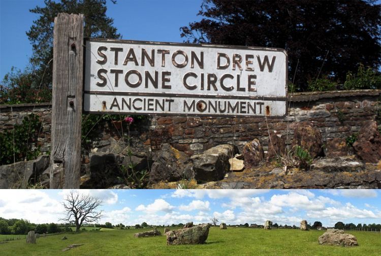
Stanton Drew is located about 15 km south of Bristol.
- Built about 4500 years ago, ceremonial in use around 2500BC.
- The Great Circle (there are/were a total of 3 stone circles, 1 large and 2 smaller) has a diameter of 113 meters, 26 stones can still be admired and that is what you can still see today!
- 4500 years ago there were those 9 concentric rings with wooden poles, Each pole was about 7 meters high! In Woodhenge, on the Stonehenge site, there were also wooden poles, but Stanton Drew is/was the largest and most (ex-) complex wooden monument in Great Britain!
- What is a Woodhenge?
- Around the Great Circle a large ditch of about 7 meters wide with a diameter of about 135 meters, Surrounded by probably 1 or 2 earthen walls, in short, a very impressive henge.
- And what is a Henge, is explained in this story:
- On the North-East side of the Great Circle an entrance about 50 meters wide. At this entrance there were 4 extra high wooden poles in a square. Around this square there were extra large heavy stone blocks, how they got them there and put them upright is still a mystery. Perhaps brought in via the nearest river Chew???
- Such a 'square-in-circle' or 'four-poster' construction I have never come across elsewhere in the country, but they seem to be there. What was the purpose of this square-in-circle' or 'four-poster' construction, maybe the basis for a podium at a ceremony or something, no one knows.
- The most special thing about Stanton Drew is that the alignment is the same as that of the Stonehenge stone circle: the line running through the center of the two smaller circles of Stanton Drew and the cove is the same as the main alignment for Stonehenge: with the winter solstice sunset in the southwest and the summer solstice sunrise in the opposite direction of the northeast!
- Let me explain, what is a Solstice::
- In short, a visit to Stanton Drew is recommended, it's also nice and quiet there of course, without the above information understandable?
- The high density wooden (timber) post monument top view
- The high density wooden (timber) post monument side view
- Around the Great Circle a large ditch of about 7 meters wide with a diameter of about 135 meters, surrounded by probably 1 or 2 earthen walls, in short a very impressive henge
- Maybe there was a roof on it???
- Overview
- On the North-East side of the Great Circle an approx. 50 meter wide entrance
- On the North-East side of the Great Circle an approx. 50 meter wide entrance with 'square-in-circle' or 'four-poster' construction, enlarged
There is a stone circle trail from Cornwall via Stonehenge, Avebury and Stanton Drew stone circles, see the following image:
Image is from this chapter:
If you have arrived there, and you don't know the story behind it, then people quickly think, what am I doing here (experience as a tour guide), this is what you get to see:
And of course the cove, in the garden of a pub, see the fourth image from the top or the second bottom, in the following image:
What is a cove, can be found here:
Why is Stanton Drew so interesting? Stanton Drew originally had 9 concentric rings with wooden poles, each pole was about 7 meters high, where they got them from is still a mystery.
Stanton Drew is/was the largest and most (ex-) complex wooden monument in Great Britain! Usually described in English as a high density wooden (timber) post monument.
Some details before we explain Stanton Drew with some images:
- After that of course the key question:
WHY ALL THOSE GIGANTIC WOODEN POLES
Last but not least, the key question is of course:
WHY ALL THOSE GIGANTIC WOODEN POLES
My answer has always been, with an example from Uzbekistan, where I once went as a tour guide with a large group, see the top image below:
The local guide in Uzbekistan told me that each pole was maintained by a family / clan etc, the family / clan came to their pole to celebrate happy and sad events together as a family / clan or to commemorate it. In short, it was a place for meetings with the family / clan etc, just like we do, for example, at a funeral / cremation etc. or afterwards at a get-together, whether or not together, at a tombstone, for example.
The guide in Uzbekistan also said that no deceased people were buried under or near the poles and that is also not the case with high density wooden (timber) post monuments
In short, the poles symbolize individual/group meeting places, and the architect has also incorporated this in the design of the visitor center of the Stonehenge site, See the bottom image below. A few times I have seen group photos taken at the poles at the visitor center!
| Back to the INDEX |
|---|
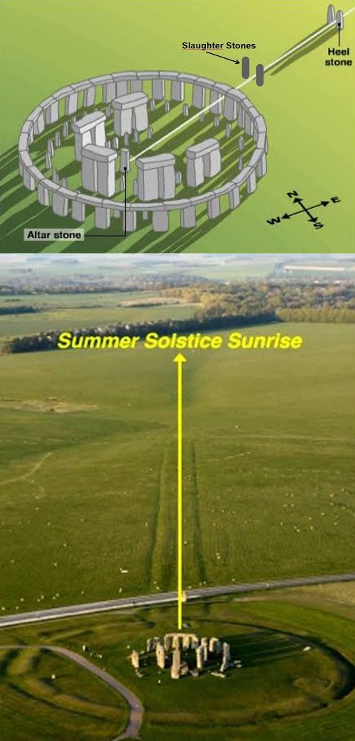
20. Heel Stone, Slaughter Stone and Altar Stone are very special Stonehenge stone circle stones
-
The Heel Stone was originally with two, the Heel STONES.
- Midsummer Solstice sunrise, over the top of the remaining right Heel Stone
- Midwinter Solstice sunrise, through the opening of a Trilithon
- Magnification Midwinter Solstice sunrise, through the opening of a Trilithon
- HEALING STONE, you always see visitors who put their hand on the Heel Stone and then meditate.
- HEEL would be a corruption of the Greek HELIOS or the SUN.
- This is always the nicest explanation, I think, a myth: FRIAR'S HEEL. None other than Geoffrey of Monmouth, the author of the Historia Regum Britanniae (History of the British Kings from 1200 BC to AD 689) published in 1137, which includes the story of King Arthur (and in another book Merlin), describes the following myth:
The devil bought large stones from an old woman in Ireland, the devil took them to Salisbury Plains and dropped one into the River Avon.
The remaining stones were placed upright near the current Stonehenge site and the devil then shouted that nobody would ever know how these stones would have ended up here and put upright.
A monk (English Friar) then shouted to the devil that this would happen one day. The devil then became so angry that the devil pulled one of the stones out of the ground and threw this stone at the Friar, the stone hit the heel (English Heel) of the Friar and then stood upright, to this day! Hence the name FRIAR'S HEEL.
The (overturned) Slaughter Stone originally also had two, the upright Slaughter STONES.
The Heel Stones and the Slaughter Stones are part of the Alignment Stones, I always found much clearer.
Of the now fallen (and from outside the stone circle not visible) Altar Stone there was only one.
This chapter on this webpage includes SELECTED REFERENCE LINKS which can be found on this webpage
ALL REFERENCE LINKS can be found on this webpage in the INDEX on this web page, of course highly recommended!
SELECTED REFERENCE LINKS:
The ceremonial Avenue runs from the River Avon to the Stonehenge stone circle
Something about Solstices, Equinoxes, Annual festivals including the Yule / Yule festival, important in understanding Stonehenge
The mysterious Durrington Walls and Woodhenge
Quotes:
-
The all-important function of the Avenue, it was discovered, is that the direction of the Avenue coincides exactly with the sunrise of the Midsummer Solstice.
The Stonehenge stone circle was "aligned" on or around the Midsummer Solstice, however, the biggest festivities in the following years were celebrated NOT on or around the Midsummer Solstice, BUT on or around the Midwinter Solstice
The Station Stones are of course also very special Stonehenge stone circle stones, the story about the Station Stones, important for the alignment of the Stonehenge stone circle, comes in the next chapter, which also discusses the different sunrises and sunsets during the Midsummer solstice and Midwinter solstice, including a diagram:
Let' s get to know, from bottom to top, the Heel Stone, Slaughter Stone and the now fallen 6000 kg heavy Altar Stone:
What were the Heel Stones and the Slaughter Stones for?
They were Directions to align the sunrise of the Midsummer Solstice through the center of the Avenue (the Avenue coincides exactly with the sunrise of the Midsummer Solstice) with respect to the Altar Stone. If you follow this Guideline from the Heel Stone to the Altar Stone and then continue straight ahead, you will know where the sunset takes place during the Midwinter solstice.
However, if you walk perpendicular to the left or right at the Altar Stone, imaginary, you know where the sunrise is during the Midwinter solstice and the sunset during the Midsummer solstice, brilliant right?
Coincidence, the fallen Altar Stone is exactly perpendicular to the above-mentioned Directive and thus indicates the direction of the sunrise during the Midwinter solstice and the sunset during the Midsummer solstice
See the 2 following images:
More about this in the next chapter:
English Heritage has placed a two-sided arrow with text next to the Heel Stone, don't miss it!
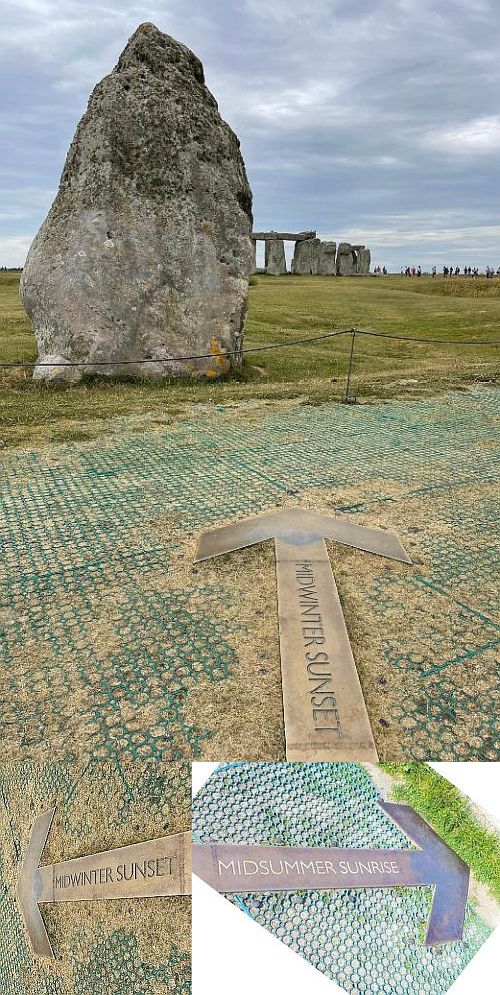
The left arrow pointing towards Stonehenge points to the sunset point during the Midwinter solstice, the arrow on the right points to the sunrise point of the Midsummer Solstice, sometimes confusing, I have experienced, the right arrow points to the point where the sun rises during the Midsummer Solstice and so on
Perhaps you have already noticed that the rising sunbeam of the Midsummer Solstice falls NEXT TO the still present Right Heel Stone and Slaughter Stone, while anno NOW the rising sunbeam of the Midsummer Solstice falls just over the top of the right remaining Heel Stone (right as seen from the Stonhenge stone circle)? And that produces many beautiful pictures and rightly so!
How is that possible, explanation:
The axis of rotation of the earth has changed somewhat due to tilt. When the Stonehenge stone circle was built, the axis of rotation was 24 degrees, and now the axis of rotation is 23.5 degrees. This small change has caused the position of the sunrise of the summer solstice to shift about 0.5 - 1 degree to the right (eastward).
About 5000 years ago, the sun rose at left of the point of the current right Heel Stone, now exactly on the tip of that Heel Stone.
And of course now some beautiful images of sunrises:
From top to bottom:
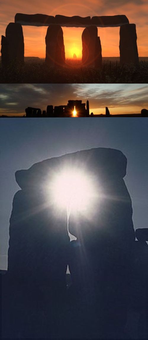
And indeed also on the print below, I think it once hung in the Stonehenge Visitor Center, the Yule party at the Stonehenge stone circle, watching the Midwinter Solstice sunrise in the snow, through the opening of a Trilithon
In the Durrington Walls chapter there are more arguments why the Winter Solstice was much more important than the Summer Solstice. And fortunately, BBC News also pays attention to the celebration of the Winter Solstice at the Stonehenge stone circle and it is usually said that the celebrated Winter Solstice (Yule) was celebrated much more exuberantly than the Summer Solstice (Litha).
Finally, some details about the Heel Stone, the Slaughter Stone and the Altar Stone.
HEEL STONE
De Heel Stone is about 3 meters wide with a circumference of almost 8 meters.
De Heel Stone is over 6 meters high, of which about 1 meter is underground.
From the Heel Stone to the Altar Stone it is about 80 meters walking.
Where does the name HEEL come from, limit myself to three possibilities:
SLAUGHTER STONE
Slaughter Stone is a very misleading name.
Our Victorian ancestors thought that on this one, with some red colored water on the stone, ritual sacrifices would have been performed.
Nonsense of course, after the remaining current Slaughter Stone fell, acid rain affected the iron in the stone, causing red rust spots when it rained.
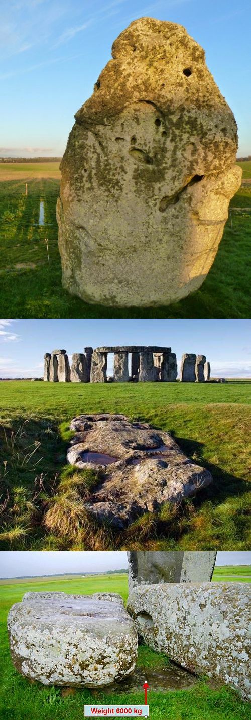
The Slaughter Stone is about 6 meters long and weighs over 4 tons.
Most of the Slaughter Stone has sunk into the ground, so probably the Slaughter Stone is much bigger than what we can see now!
ALTAR STONE
Not much about it in my notes, there is also, in my opinion, little known about it?
The Altar Stone weighs about 6 tons and is about 6 meters long.
It is interesting where all the stones come from, but we will come back to that in one of the next chapters.
| Back to the INDEX |
|---|
21. The (John) Aubrey holes are important for both the creation and alignment of the Stonehenge stone circle
- Durrington Walls reconstruction, with arrows from left to right: Woodhenge of South Circle (?), Wall, Durrington Walls Avenue, River Avon
- Behind the visitor center are a number of historically accurate Neolithic houses. The inhabitants of the Durrington Walls Neolithic houses have been involved in the construction of the Stonehenge stone circle.
- Behind the fence around Woodhenge a piece of the Wall of Durrington Walls
- Of the once undoubtedly imposing Durrington Walls there is now little more than just a "basin" as it is called, or a still visible large shallow pit.
- Later the earthen wall was provided with about 7 meter high wooden poles, WHY??
And again the question where were all those wooden posts (timber posts) taken from and what a job to put them all upright at regular distances! WHY??
Initially it was thought that there were stones instead of wooden poles, but that turned out to be incorrect.
- As 5, but now enlarged, note the height of the 7 meter high poles compared to a man
- Later the earthen wall was provided with about 7 meter high wooden poles, WHY??
- There are about 20 (small) yellow dots to be found: Around 2020, in a circle of about 2 km, far outside the Durrington Walls, wells were discovered in which a complete Trilithon would fit, again the question WHY?? So far, about 20 of these gigantic pits have been discovered! It is now also called the largest prehistoric monument in Great Britain.
- What dimensions of such a mysterious well, containing a Trilithon
- The high density wooden (timber) post monument top view
- The high density wooden (timber) post monument side view
- Around the Great Circle a large ditch of about 7 meters wide with a diameter of about 135 meters, surrounded by probably 1 or 2 earthen walls, in short a very impressive henge
- Maybe there was a roof on it???
- Overview
- On the North-East side of the Great Circle an approx. 50 meter wide entrance
- On the North-East side of the Great Circle an approx. 50 meter wide entrance with 'square-in-circle' or 'four-poster' construction, enlarged
- Midsummer Solstice sunrise, over the top of the remaining right Heel Stone
- Midwinter Solstice sunrise, through the opening of a Trilithon
- Magnification Midwinter Solstice sunrise, through the opening of a Trilithon
This chapter on this webpage includes SELECTED REFERENCE LINKS which can be found on this webpage
ALL REFERENCE LINKS can be found on this webpage in the INDEX on this web page, of course highly recommended!
SELECTED REFERENCE LINKS:
What is a Henge?? (Organic Growth)
The ceremonial Avenue runs from the River Avon to the Stonehenge stone circle
Something about Solstices, Equinoxes, Annual festivals including the Yule / Yule festival, important in understanding Stonehenge
Heel Stone, Slaughter Stone and Altar Stone are very special Stonehenge stone circle stones
The Stanton Drew Stone Circles and Wood Circles ("Woodhenges")
RECOMMENDED EXTERNAL LINK:
This chapter also discusses the STATION STONES and the Q&R AND Y&Z HOLES.
We start this chapter with some images from some reference links, To get an idea of what this chapter will be about: among other things, about wooden poles of 4 - 7 meters high, where were they taken from???
1.
Unfortunately not in the reference links, so go to the index and choose chapter 9. When did stone circles, like the one of Stonehenge, start with a henge
In the image below a Woodhenge like the one that occurred with the Maya!
The Native Americans even built Woodhenges around the year 1000, so only 1500 years ago, with a diameter of about 125 meters, for which 48 red painted cedar poles were used.
Why they did this and e.g. also the Mayans, it is assumed to be able to record the different year seasons or the position of the sun!
2.
Unfortunately not in the reference links, So go to the index and choose chapter 18. The mysterious Durrington Walls and Woodhenge
It is now image 5 and 6 in the composite image above:
Explanation from top to bottom:
3.
From the reference link The Stanton Drew Stone Circles and Wood Circles ("Woodhenges")
A somewhat long quote indeed, but Stonehenge could also have been as Stanton Drew ("Organic Growth"), at Staton Drew a lot of wooden poles have indeed been used, WHY??
- After that, of course, the key question:
WHY ALL THOSE GIGANTIC WOODEN POLES
Last but not least, the key question is of course:
WHY ALL THOSE GIGANTIC WOODEN POLES
My answer has always been, with an example from Uzbekistan, where I once went as a tour guide with a large group, see the top image below:
The local guide in Uzbekistan told me that each pole was maintained by a family / clan etc, the family / clan came to their pole to celebrate happy and sad events together as a family / clan or to commemorate it. In short, it was a place for meetings with the family / clan etc, just like we do, for example, at a funeral / cremation etc. or afterwards at a get-together, whether or not together, at a tombstone, for example.
The guide in Uzbekistan also said that no deceased were buried under or near the poles and that is also not the case with high density wooden (timber) post monuments
In short, the poles symbolize individual/group meeting places, and the architect has also incorporated this in the design of the visitor center of the Stonehenge site, See the bottom image below. A few times I have seen group photos taken at the poles at the visitor center!
This complex chapter about the Aubrey holes and much more, is discussed with the help of the images below, indeed there are quite a few, hence an explanation for each numbered image......
To be honest, as a Cultural Historical Tour Guide I have never been that concerned with astronomical theories, so that's why sometimes only what I found in my notes and tried to explain during a tour
However, it was often experienced as special that we, looking for an Aubrey hole, sometimes stood with our backs to the Stonehenge stone circle, which sometimes gave some strange reactions from other visitors:
WHAT ARE YOU LOOKING AT NOW??
================================
Below the next 2 composite images, the numbered images are discussed 1 by 1:
Explanation of image 1 of the above composite images
In 1666 a certain John Aubrey took a walk along the Stonehenge stone circle and discovered five circular holes in the ground, just outside the Stonehenge stone circle and made a record of them as well, which fell into oblivion in the course of the following centuries. Until the beginning of the 20th century!
John Aubrey was, among other things, a antiquarian, of the Latin antiquarian 'belonging to antiquity', who, unlike today, probably did not deal in objects. At the time, an antique dealer was mainly a lover of historical objects and places.
In the years 1920 to 1950 many more circular holes were discovered, eventually there turned out to be 56! And of course they were named after the discoverer, hence the now established name Aubrey holes.
The Aubrey holes have an average diameter of 1.06 m and are on average 0.76 m deep. The Aubrey holes are a very carefully constructed circle with a circumference of 271.6 m, all 56 at exactly the same distance from each other, VERY CLEVER!
The earthen wall of the henge is about 5 meters outside the Aubrey holes, from the Aubrey holes to the Stonehenge stone circle it is about 30 meters.
Total are now 35 Aubrey holes investigated. We will come back to the results of course.
What was the purpose of the Aubrey holes? More on that below.
It is clear that the Aubrey holes had long since disappeared when the Stonehenge stone circle was built. In the construction of the Stonehenge stone circle, use was certainly made of the holes left over from the Aubrey holes in terms of positioning, more on that later.
Explanation of image 2 of the above composite images
The diameter of the Aubrey hole circle to the diameter of the earthen wall is equal to the average diameter of the sun, the diameter of the later built Stonehenge stone circle is equal to the average diameter of the moon, it was once determined. Several prehistoric monuments from the time of Stonehenge have used this ratio between the average diameters of the moon and the sun!
In short, Stonehenge functioned as a Moon temple, is the general opinion! It was once summed up so well: The sun belongs to the day, life, light and growth. The moon to night, death, darkness and dying. Stonehenge was designed to honor the deceased! At Stonehenge, a final ceremony was performed for the deceased before they were buried in one of the hundreds of burial mounds at the Stonehenge site. And in or near the Aubrey holes, more on that later.
There are a total of 56 Aubrey holes, or 2x 28. A Moon month lasts about 28 Moon Days, to be precise 29.5 Moon Days, but in the time of Stonehenge it was calculated with 28 Moon Days. A menstrual cycle, of course they already knew at the time, lasts about 28 Moon Days, so 56 Aubrey holes are two menstrual cycles! In short, wooden poles of possibly 4 meters in length were placed in the 56 Aubrey holes, which were removed one by one, and that after every Moon Day.
If I understood correctly, the 28-day lunar cycle is followed by moving a wooden pole representing the moon with two holes counterclockwise each day, which ends with a total of 56 holes. By moving a different wooden pole, representing the Sun, two holes counterclockwise every 13 days, an annual cycle could also be kept.
According to some, there were no wooden poles in the 56 Aubrey holes but stone poles, because in some Aubrey holes stone remains were found, identical in composition to the Bluestones of the Stonehenge stone circle. But the majority is in favor of wooden poles, a bit more practical right?
In short, the 56 Aubrey holes acted as an astronomical Moon Calendar. By adding, moving or removing wooden posts in a systematic way, INGENIOUS.
And of course this was also very useful to keep track of the change of seasons, necessary for agriculture, for example.
Explanation of image 3 of the above composite images
A beautiful stylized image of the 56 Aubrey holes, with year and Heel Stone. And oriented in the right North, South, East, West directions.
Without the Stonehenge stone circle, because it still had to be built, see the image below:
The question remains, of course, where did pole 1 stand? Quite handy with an astronomical Moon Calendar, where wooden poles were added, moved or removed in a systematic way, see explanation above, at image 2.
It has been assumed that if you walk from the Heel Stone to the Aubrey Holes, the first position immediately to the left past the earthen wall was position 1, and then clockwise to position 56, see also figure 8.
Explanation of image 4 of the above composite images
A fantasy image as it could have been created, according to the principle of Organic Growth.
- In Chapter 14. What are the Lesser Course and the Stonehenge Course on the Stonehenge site, north of the Stonehenge stone circle (to be found via the index) is another beautiful fantasy image, it is the second image below, from the Stonehenge course:
During my tours I always told the following story, about all those wooden poles and a great discovery in the Aubrey circle, possibly it happened like this, according to Organic Growth!
56 wooden poles of about 4 to 7 meters high, where do you get it from. At the Aubrey holes it was still a bit manageable, but at Stanton Drew, hundreds (?) of wooden poles, because of course there also had to be a stock, after all, wood will rot over time.
Also by removing, moving and reinserting the Aubrey wooden posts, the wooden posts will undoubtedly be damaged. Also, they were probably not unprocessed wooden poles, the oak (it is assumed) poles were all made identical in length and surface roughness and then, it is assumed, religious or non-religious decorations were applied to them.
See the following fantasy image of Woodhenge, Woodhenge is unfortunately not in the reference links, so go to the index and choose chapter 18. The mysterious Durrington Walls and Woodhenge
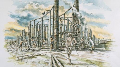
The wooden poles are also called Druid poles, because Druid them, Who knows, have consecrated or something like that. Another frequently heard name is of course Totem Pole.
Where were the oak (?) wooden poles taken from, remains unclear, this is known about the Stonehenge stones, we will come back to this of course.
Did the wooden poles come from the vicinity of present-day Stonehenge, so from Salisbury Plain, a large chalk plateau of about 800 square km, of which now, about half is reserved for military use, as Salisbury Plain Training Area? In short, would there ever have been so many oak trees on such a desolate site, hence the Salisbury Plain Training Area?
I am of the opinion that the oak (?) wooden poles had to be taken from somewhere else. But from where? Opinions are divided.
It is clear that for the felling of the trees, the processing and installation of all those oak (?) wooden poles, at least dozens of people may have been involved or maybe even more, especially with all those oak (?) wooden poles from Stanton Drew!
And then, Organic Growth, it is discovered that the sunrise at the Summer solstice is on the same line as the sunset of the Winter solstice. About halfway on the said line, perpendicular to another line, connects the sunset during the Summer solstice with, in a line, the sunrise of the Winter solstice. (see also Figure 11).
We now know that this is no coincidence, because the chosen location of the Aubrey holes and therefore also Stonehenge is on the 51st degree of latitude. Only at this place, on the 51st degree of latitude, are these two perpendiculars so possible, I have been told. A lot has been written about the fact that Stonehenge is located on the 51st degree of latitude!
I understand all this exactly, as a tour guide I don't either, I gladly accept it, because I imagine that people who lived in and around the fantasy image 4, gradually found out about those two perpendiculars or, and this is also assumed, they started here consciously, on the 51st degree of latitude with the construction of the 56 wooden poles circle, discovered in 1666 by Aubrey. A very accurately constructed circle with a circumference of 271.6 m, all 56 at exactly the same distance from each other, VERY CLEVER!
Finally, of course it has been historically chronologically different than I always told, between the creation of the Aubrey holes and something that will look like a stone circle there are at least 5 centuries, but the question remains, was the location of Stonehenge on the 51st degree of latitude deliberate or not?
Explanation of image 5 of the above composite images
But the wooden posts in the Aubrey holes could also have served as a open visual separation, you can also read here and there, as in image 5, and a lot of fences, such as low so-called open willow fences.
What is more likely is that the Sarsen Stones (see image below) were indeed intended as a visual partition.
It is also assumed that the inward-facing sides of the Sarsen Stones were smoothed, according to some even provided with a light colour, but whether that was already possible about 5 centuries ago??
In the next chapter we actually come across a real wall as a partition:
Explanation of image 6 of the above composite images
An aerial view of the Aubrey holes, enlarge this image and discover the red circles at the top left, with some effort you can also discover the other red circles.
At the bottom an Aubrey hole is examined, most Aubrey holes were already investigated about 100 years ago, 35 of the 56 Aubrey holes have been investigated so far.
What was found, in addition to stone remains, human cremation remains, sometimes upright, sometimes in leather bags! Sometimes even mutilated and disfigured!
The wooden poles were of course long gone, when the Stonehenge stone circle was built. There are at least 5 centuries between the creation of the Aubrey holes and something that will look like a stone circle!
On the Stonehenge site, and especially in the vicinity of the Stonehenge stone circle, a total of more than 50,000 cremated remains of 63 people (men, women, children) have been found.
That is why the Stonehenge site is also called Britain's oldest cremation cemetery called!
You can assume that the closer to the Stonehenge stone circle buried, the more important the deceased male (?) persons were, but human remains have also been found of women from Wales, probably mainly from the region where the Bluestones came from, we will come back to this of course.
Human remains from the Iberian Peninsula (Spain, Portugal) have even been found, from which the conclusion can be drawn that Stonehenge was already known in continental Europe, even in the southern regions, and that efforts were made to transfer human remains to Stonehenge as well. But of course they could also have been visitors who also undertook a long journey back then and came to Stonehenge to possibly participate in one of the ceremonies and then died. The most important ceremony at Stonehenge was the winter solstice and not the summer solstice.
A famous example of an excavated person is the Stonehenge Archer, lived between 2400-2200 BC. Found during an excavation in the henge ditch around Stonehenge in 1978. The remains belonged to a man, between 25 and 30 years old. He turned out to have several wounds, which were apparently caused by arrows. Three arrowheads were found during the excavation.
I once visited his skeleton in the Salisbury Museum with a number of people, highly recommended:
In the image below from top to bottom, the Stonehenge Archer and an overview of the Aubrey holes cremation burials, we will come back to the Y and Z holes. (image 8)
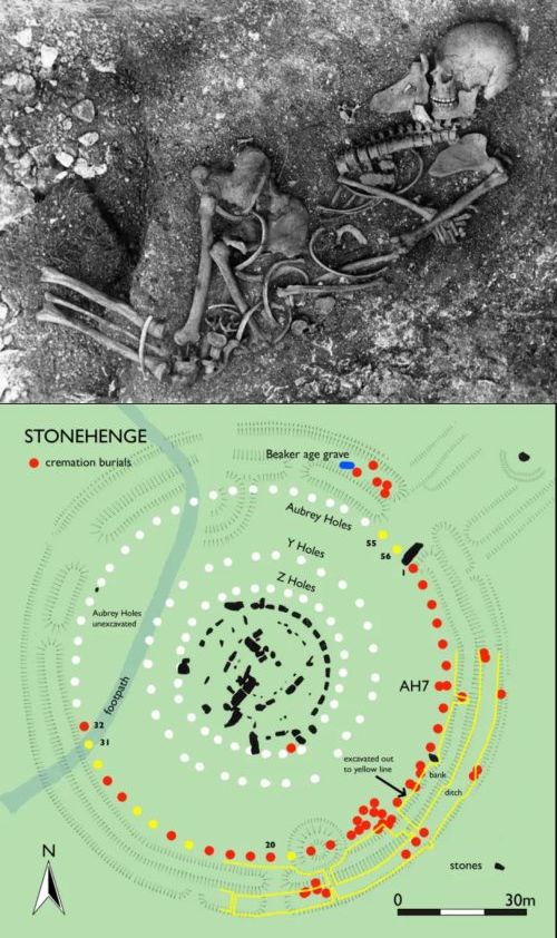
Explanation of image 7 of the above composite images
If you walk from the Stonehenge stone circle in the direction of the visitor center, you will automatically pass the Aubrey holes circle, with a Station Stone nearby (we will come back to image 9 of the composite images above).
And somewhere in the Aubrey holes circle are one or more Aubrey holes covered with gravel. Why, I can no longer find in my notes, in any case they are Aubrey holes that have not yet been investigated in terms of cremation burials, see above: the bottom image at the end of the explanation to image 6 of the above composite images.
While we are looking at this gravel-covered Aubrey hole with the group, with our back to the Stonehenge stone circle, a Dutchman comes to us from the Stonehenge stone circle with the, for me, unforgettable comment:
WHAT ARE YOU LOOKING AT NOW??
Explanation of image 8 of the above composite images
Difficult story for me has always been about the Y, Z, Q and R holes.
In my notes I really only found this:
The Q and R holes originated around 2600BC INSIDE the Sarsens circle, the Y and Z holes were created 1000 years later (so around 1600BC) OUTSIDE the Sarsens circle.
In my notes it also says, find out why these Y, Z, Q and R holes were installed and what was the purpose?? And so I found some quotes on the internet:
For a more than excellent explanation I would like to refer to the RECOMMENDED EXTERNAL LINK, outlined in the green rectangle with recommended links just below the beginning of this Chapter 21 The (John) Aubrey holes are important for both the origin and the alignment of the Stonehenge stone circle.
Quote from the RECOMMENDED EXTERNAL LINK:
-
The three circles (Aubrey holes (X) and Y and Z) together form a Lunar Standstill calendar.
The inner two circles consist of 29 holes, the Z-holes, and 30 holes, the Y-holes. In addition, there are exactly two complete (Synodic = 29.5 days) Moon cycles from, for example, full to full. The outer X circle consists of 56 holes and bears the name of its discoverer Aubrey-Holes. If we now multiply these two lunar cycles by this number 56, we arrive at a total of 112 synodical lunar cycles. This is exactly the number of cycles, for the shortest period, between two consecutive lunar standstills.
Very small quote from the RECOMMENDED EXTERNAL LINK:
At the same time, the stone from hole 2 of the Aubrey-Holes is moved to hole 3. Now the stone in the Y-holes is moved one hole every day, counterclockwise, until Y30 is reached. The next day it is New Moon again and the stone of hole Y30 is placed in hole Z1 again. At the same time, the stone of hole 3 of the Aubrey-Holes is placed in hole 4. Each New Moon is counted, counterclockwise, until Aubrey-Hole 56 is reached.
As for the Q and R holes, this was well known to me, quote from Wikipedia:
The Q and R holes are a series of concentric holes that currently form the earliest known evidence of a stone structure at the location of the Stonehenge stone circle.
Under the grass and just inside the later Sarsen Circle is a double arch of buried stone holes, the only surviving evidence of the first stone structure (possibly a double stone circle) that was erected in the center of Stonehenge and is currently considered to be the beginning of the period known as Stonehenge Phase 3. (see bottom image at Explanation figure 3, just above the start of the Explanation image 4 of the above composite images.) Hopefully to find it?
Of course we will come back to the origin of the Stonehenge circle.
Explanation of image 9 and 10 of the above composite images
I would almost say, finally we come to the title of this chapter 21:
Figure 9 is the westernmost Station Stone, and then of course the question arises: what is a Station Stone?
Literally, a Station Stone means a Pitch, Position or Station Stone. In short, a Station Stone indicates a position, the Aubrey holes circle was used to place the Station Stones in PREDETERMINED positions.
What is described below reflects how I have always told it during tours, mixed with what is behind it.
And then I always ended my story with the remark, GENIUS that this was already consciously done about 5000 years ago, Only in the present century has the principle slowly become clear, I have always understood! But, keep in mind, there has been debate for years whether this was indeed done this way on purpose, about 5000 years ago.
4 Station Stones were selected, sandstones with an estimated weight above ground of 2.78 tons, as shown in Figure 9. Of the 4 Station Stones only 2 are now left, the other 2 have been replaced by small empty burial mounds with their own henge structure, the shape, it is said, resembles an open letter D.
The small empty burial mounds with their own henge structure are indicated by modern stone and steel markings in the Aubrey holes circle, Unfortunately, they are hardly noticeable.
Why the burial mounds replaced 2 Station Stones is still a mystery, it is also a mystery why the burial mounds have remained empty.
At the end of this explanation of figures 9 and 10, another image showing both a Station Stone and the Stonehenge Stone Circle.
A Station Stone is therefore much lower than the Stonehenge Stone Circle and therefore, just like the small empty burial mounds, the Station Stones are hardly noticed by many people, I usually had to walk there with the whole group.
When we walked there, we always walked to the Eastern Station Stone. This Eastern Station Stone is deliberately (?) placed at Aubrey Hole number 10.
In terms of Aubrey Hole number count: it has been assumed that if you walk from the Heel Stone to the Aubrey Holes, the first position immediately to the left past the earthen wall was position 1, and then clockwise to position 56.
The diameter of the Aubrey holes circle is 87 - 88 meters, From Aubrey Hole number 10 the diameter of 87 - 88 meters to the other side of the Aubrey holes circle, ends up at Aubrey Hole number 38. Mathematically this is of course correct, because there are a total of 56 Aubrey holes, 28 on each half of the Aubrey holes circle, if you add 10 to Aubrey Hole number 28, you will also automatically arrive at Aubrey Hole number 38.
And then the GENIALE, from the Aubrey Holes numbers 10 and 38 mathematical lines are plotted that are parallel to the yellow Solstice line, as seen in the image below, from the reference link Heel Stone, Slaughter Stone and Altar Stone are very special Stonehenge stone circle stones.
From the Aubrey Holes number 10 and 38, parallel to the Solstice line, you then arrive at the Aubrey Holes number 17 and 45, coincidentally (?) both now empty burial mounds.
SUMMARY: The 4 Station Stones were deliberately placed (GENIUS) as close as possible to the Aubrey Holes numbers 10, 17, 38 and 45. Only at the Aubrey Holes numbers 10 and 38 there are still Station Stones, at the Aubrey Holes numbers 17 and 45 the Station Stones have been deliberately (?) replaced by empty burial mounds in the shape of an open letter D.
As a reminder: a Station Stone has an estimated weight above the ground of 2.78 tons, so much admiration how 5000 years ago the 4 Station Stones were placed on their predetermined Aubrey hole position, you will be wrong about Aubrey hole position.
Once, during one of my tours, someone got the impression that the 4 Station Stones were some kind of easily movable pawns! A minimum Station Stone weight of 2.78 tonnes had not gone over well.
And now to image 10, one of my favorite Stonehenge images, always showed it!
The yellow Solstice line from the image above has now turned green. The 4 Aubrey Holes number 10, 17, 38 and 45 can also be found, together they form a rectangle within the Aubrey Holes circle with rectangle sides in the ratio of 5:12. The diagonals in the rectangle intersect in the center of the Stonehenge stone circle. I have always assumed that the Altar Stone is placed at the intersection of the rectangle diagonals, but that doesn't seem to be true, so be it!
But, in summary, it will hopefully be clear that the (John) Aubrey holes were important for both the creation and alignment of the Stonehenge stone circle, without the Aubrey holes there would be no Stonehenge stone circle.
SO, what is the meaning of the vertical and horizontal sides of the rectangle: the vertical lines of course stand for the Solstices and the horizontal sides??
It is assumed that the horizontal sides of the rectangle are related to the farthest northern setting of the Moon and the farthest southern rising of the Moon during a year of the Great Lunar Standstill. The sun and moon extremes, as it is called, are indeed perpendicular to each other or at an angle of 90 degrees and apparently people already knew that about 5000 years ago, UNBELIEVABLE, if you realize that and start thinking about it! And all this has been used in practice in the creation and alignment of the Stonehenge stone circle, with the help of the Aubrey holes that were added 5 centuries earlier. GENIUS.
The farthest northern setting of the moon and the farthest southern rise of the moon, (called great lunar standstill) that of course requires an explanation: the sun follows a cycle of about a year, the moon goes from the southernmost to the northernmost borders and back again within a month. But the moon also follows another cycle: the boundaries of the moon's setting and moonrise change over a period of about 18.6 years.
By the way, from the word MOON our word MONTH is derived.
A great lunar standstill (also called lunistice) occurs when the farthest southern and farthest northerly rise and fall of the moon occurs, according to my notes, hopefully it's right?
Once understood, that if you were to mark the position of moonrise and moonset in a month, the moon moves between two points on the horizon. These southern and northern boundaries of moonrise (or set) change in an 18.6-year cycle between a minimum and a maximum range - the so-called minor and major lunar standstills, respectively.
It is believed that at least 1 major lunar standstill was observed during the early build-up phase of the Stonehenge Stone Circle, which may also have influenced the formation and alignment of the Stonehenge Stone Circle.
In 2024 I understood on the BBC, a major lunar standstill took place and it would be investigated whether this was indeed applied in the formation and alignment of the Stonehenge stone circle. I have yet to find the results!
Image 10 also shows the Y and Z holes, which is almost always done with these types of images.
The explanation for image 8 also states this:
Quote from the RECOMMENDED EXTERNAL LINK:
-
The three circles (Aubrey holes (X) and Y and Z) together form a Lunar Standstill calendar.
The inner two circles consist of 29 holes, the Z-holes, and 30 holes, the Y-holes. In addition, there are exactly two complete (Synodic = 29.5 days) Moon cycles from, for example, full to full. The outer X circle consists of 56 holes and bears the name of its discoverer Aubrey-Holes. If we now multiply these two lunar cycles by this number 56, we arrive at a total of 112 synodical lunar cycles. This is exactly the number of cycles, for the shortest period, between two consecutive lunar standstills.
Finally, 2 more images:
The top image shows the ratio in size between a Trilithon and a Station Stone in the background on the right, a small tapered rounded stone, you have to know where to find it, otherwise he won't stand out and you'll miss him!
The bottom image is a beautifully summarized styled diagram of the alignment rectangle as we discussed above, all including the Aubrey holes and the Y and Z holes. I can look at this for hours and realize and marvel again and again that these principles were already known 5000 years ago. GENIUS
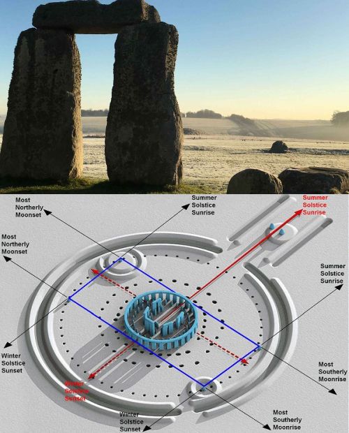
Explanation of image 11 and 12 of the above composite images
TRANSLATION DUTCH TO ENGLISH IMAGE 11:
|
ZON MAAN NOORDELIJK ZUIDELIJK ONDERGANG OPGANG MIDZOMER MIDWINTER |
SUN MOON NORTH SOUTH SUNSET SUNRISE SUMMER SOLSTICE WINTER SOLSTICE |
Just like image 10 (described above) image 11 is one of my favorites, have always used image 11 as an example for the different positions of sun phases and moon phases.
From / next to the Heel Stone towards the Stonehenge stone circle the famous, well-attended Midsummer Solstice sunrise takes place on/around the longest day, described in various places on this web page, linked to the Midwinter Solstice sunset, because on the same line down from / with the Midsummer Solstice sunrise.
Question came up often, how can you remember that the Midsummer Solstice sunset is to the left of the Midsummer Solstice sunrise. My answer was always, the sun rises in the East and sets in the West, so the sun goes from the Eastern Midsummer Solstice sunrise to the Western Midsummer Solstice sunset, so from right to left.
You can also remember it if you know this well-known Advent song, I always said:
-
"Now it dawns in the east" announces the coming of the light or the sun (and therefore Christ). An original medieval song about a young woman who enters a monastery, later it was also, more famously, about the coming of the Light, in the person of Christ.
In the reference link Something about Solstices, Equinoxes, Annual Festivals including the Yule / Yule Festival, important in understanding Stonehenge you can also find this information about our Christmas compared to the much older Joel/Yule festival:
-
The Summer Solstice is also called St. John's Day, the celebration of the birth of John the Baptist. Especially celebrated at the Waldorf Schools!
The Winter Solstice has indeed become our Christmas, the lights in the Christmas tree symbolize the stars in the sky, the peak symbolizes the pole star, the garlands the milky way, according to tradition!
How did Christmas originate instead of the Yule feast, In summary:
On December 25, the Romans celebrated the Winter Solstice, the Dies Natalis Solis Invicti. The God Mithras, also known as Sol Invictus, or the Invincible Sun, was worshipped. Celebrating the birthday of the Invincible Sun was a popular custom in Rome.
In the 4e century, Pope Liberius therefore set the birthday of Christ on the same December 25 as a replacement for the Yule feast, so the choice for December 25 is not based on Biblical sources. The choice of this day can also be seen as a concession to the Romans to be converted.
Also clear in image 11, the right (so the East) is always for the sunrise, the left (so the West) is always for the sunset. In figure 12 it all becomes even clearer, but first the indicated moon phases are also shown in figure 11.
The indicated phases of the moon are the daily monthly phases of the moon, apparently they deviate slightly from the direction of the phases of the sun, so be it. These phases of the moon have nothing to do with the so-called small and large standstill, as described in the explanation of the previous figures 9 and 10.
And then an addition from the reference link Heel Stone, Slaughter Stone and Altar Stone are very special Stonehenge stone circle stones:
-
You may have noticed in the image below that the rising sunbeam of the Midsummer Solstice NEXT TO the still present judge Heel Stone and Slaughter Stone falls, while anno NU the rising sunbeam of the Midsummer Solstice falls just over the top of the right Heel Stone falls (right seen from the Stonhenge stone circle)? And that produces many beautiful pictures and rightly so!
How is that possible, explanation:
The axis of rotation of the earth has changed somewhat due to tilt. When the Stonehenge stone circle was built, the axis of rotation was 24 degrees, and now the axis of rotation is 23.5 degrees. This small change has caused the position of the sunrise of the summer solstice to shift about 0.5 - 1 degree to the right (eastward).
About 5000 years ago, the sun rose at left of the point of the current right Heel Stone, now exactly at the tip of that Heel Stone.
And of course now some beautiful images of sunrises:
From top to bottom:
And indeed also in the print below, I think there was once in the Stonehenge Visitor Center, the Yule party at the Stonehenge stone circle, in the snow watching the Midwinter Solstice sunrise, through the opening of a Trilithon
In the Durrington Walls chapter more arguments why the Winter Solstice was much more important than the Summer Solstice. And fortunately, BBC News also pays attention to the celebration of the Winter Solstice at the Stonehenge stone circle and it is usually said that the celebrated Winter Solstice (Yule) was celebrated much more exuberantly than the Summer Solstice (Litha).
Whether it is true that the Midwinter Solstice sunrise fell exactly through 2 Trilithons, that is speculation of course. All the beautiful Midwinter Solstice sunrise photos are of course all taken from the Stonehenge stone circle and not from outside the Stonehenge stone circle, as shown in the snow image.
The Midsummer Solstice sunrise photos, over the top of the remaining Right Heel Stone, are of course all taken from the Stonehenge stone circle, but a photo of a Midwinter Solstice sunrise from the snow position, so near and at least in front of the West Station Stone, right through 2 Trilithons, I've never seen it before! Whether there are also 2 Trilithons aligned like this, never paid attention, don't think that there are still 2 Trilithons in 1 line!
And then image 12, VERY NICELY WORKED OUT!
We first repeat a piece of end text from the explanation of image 10:
-
What I have always told when showing image 10, if you would consider that long green line in the direction of the Heel Stone as a LEVER, and you move this LEVER downwards clockwise (or the other way, counterclockwise) and you assume that the 4 Station Stones are some kind of pawns that fall into an Aubrey hole, but can also be dragged out again when moving the LEVER (to the next click position I have always called it) then that indicates the monthly sunrise and sunset, as is so beautifully shown in image 12.
- Also this, what was the difference between a solstice and an equinox, from the reference link Something about Solstices, Equinoxes, Annual Festivals including the Yule / Yule Festival, important in understanding Stonehenge
At a Solstice, also called Solstice, (Latin: Solstice we have a Summer Solstice and a Winter Solstice, with respectively the longest and shortest day in combination with the shortest and longest night, so on or around June 21 and on or around December 21.
At an Equinox, the days and nights are the same length, and so we have a Spring Equinox (on or around March 21, the beginning of spring) and an Autumn Equinox (on or around September 23, the beginning of autumn).
How did I get 2.3 Aubrey holes per "click": in a quarter (90 degrees) of the Aubrey Holes circle there are 56 Aubrey holes (56 is number of Aubrey holes in full Aubrey holes circle, 360 degrees) divided by 4 is 14 Aubrey holes. The LEVER must be moved 6 times from the June 21 Summer Solstice sunrise to the December 21 Winter Solstice sunrise, 14 Aubrey holes divided by 6 is per "click" 2.3 Aubrey holes.
In reality, I learned from image 12, the angle between the June 21 Summer Solstice sunrise and the December 21 Winter Solstice sunrise is not 90 degrees, but 79 degrees and so it is less than 2.3 Aubrey holes per "click".
What image 12 also nicely depicts are, as in picture 11, clockwise from the top, respectively the Summer Solstice, the Sunrise over the entire right Eastern side, the Winter Solstice and the Sunset over the entire left Western side.
And very nicely rendered, the whole is mirrored horizontally around the Equinoxes, the displacements of the LEVER above the Equinoxes line are identical to the displacements of the LEVER below the Equinoxes line. That's right, I had never realized this either!
Also nicely rendered, the angle between the Equinoxes line and the Summer and Winter Solstices is of course half of 79 degrees, 39.5 degrees.
To conclude this chapter
repeats my statement:
- Without the Aubrey holes circle built 500 years earlier than the Stonehenge stone circle, there would not have been a Stonehenge stone circle.
Always at lectures, webinars and guided tours at various times tells.
| Back to the INDEX |
|---|
22. Stonehenge is part of a larger whole, such as a compact, within walking distance, triple monument on the windswept Scottish Orkney Islands
But we're also going to talk about the North Yorkshire Stonehenge of the North: the Thornborough triple Henges
-
But first we are going to talk about, for comparison with Stonehenge, which of course also happened from about 20 years ago, various UNESCO World Heritage Sites on the Scottish Orkney Islands, such as the 3-part monument Ring of Brodgar, Ness of Brodgar and the Stones of Stennes.
And of course also something about the nearby Orkney Neolithic settlement Skara Brae and the burial mound Maeshowe, where, just like with Newgrange (Ireland) only light enters during the winter solstice!
This chapter on this webpage includes SELECTED REFERENCE LINKS which can be found on this webpage
ALL REFERENCE LINKS can be found on this webpage in the INDEX on this web page, of course highly recommended!
SELECTED REFERENCE LINKS:
What is a Henge?? (Organic Growth)
How many stone circles are there in Great Britain and what are the dimensions of stone circles, such as those of Stonehenge
Something about Solstices, Equinoxes, Annual festivals including the Yule / Yule festival, important in understanding Stonehenge
The mysterious Durrington Walls and Woodhenge
The Stanton Drew Stone Circles and Wood Circles ("Woodhenges")
RECOMMENDED EXTERNAL LINKS:
For a long time it was suspected that Stonehenge was not an isolated Neolithic monument, but was connected to other Neolithic monuments, on the Orkney Islands this was confirmed.
On this webpage (use CTRL-F) you can find this, for example:
There is even a stone circle trail from Cornwall via Stonehenge, Avebury and Stanton Drew stone circles, see the following image:
And indeed it is now assumed that Stonehenge, Avebury and Stanton Drew were connected. They started with a ceremony in Stanton Drew, then a ceremony in Avebury, to end at the Stonehenge site, where they gathered inside the Durrington Walls.
During the Yule party, sometimes up to 4000 people were present inside the Durrington Walls! Then they walked along the Avenue to the Stonehenge stone circle.
On the print below, I think once in the Stonehenge Visitor Center, the Yule party hung at the Stonehenge stone circle, in the snow watching the Midwinter Solstice sunrise, through the opening of a Trilithon
The Avebury site, see below, (henge with stones) already forms an organizational form together with the Stonehenge site, one WORLD HERITAGE SITE, so it's worth going to Avebury as well!
In summary, what was found on the Orkney Islands at the middle monument of the triple monument, the Ness of Brodgar: a
TEMPLE COMPLEX
nickname
NEOLITHIC CATHEDRAL
See the digitized image below
nickname
NEOLITHIC CATHEDRAL
See the digitized image below
Nearby the Neolithic settlement Skara Brae, where most likely the people who built the triple monument Ring of Brodgar, Ness of Brodgar and the Standing Stones of Stennes lived.
Most likely the very first stone circles in the UK.
The stone circle culture eventually ended up in the south of England via the mainland of the north of Scotland, with the Stonehenge stone circle as the highlight!
- Only now do I understand that parts of the 3-part monument Ring of Brodgar, Ness of Brodgar and the Standing Stones of Stennes were built by earlier cultures, possibly Nordic peoples. Possibly people who lived in the mesolithic, so in the period 8,000-4,000 BC, the following Neolithic was in the period 4,500 - 2,000 BC. Respectively in the Middle Stone Age and the New Stone Age.
(Greek meso = middle, neo = new, lithos = stone)
According to the reference link about the number of stone circles in the UK, there are now 508 stone circles in Scotland and in England 316 stone circles!
No doubt also, it is stated, that the inhabitants of Skara Brae, the burial mound Maeshowe built, where, with the GENIUS particularity, only light falls in during the winter solstice!
In the digitized image below the TEMPLE COMPLEX of the Ness of Brodgar:
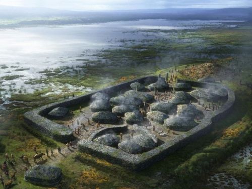
Ness of Brodgar
TEMPELCOMPLEX
nickname
NEOLITHIC CATHEDRAL
TEMPELCOMPLEX
nickname
NEOLITHIC CATHEDRAL
-
Actually, the name NEOLITHIC CATHEDRAL refers to the 10th excavation at the Ness of Brodgar site (Structure 10, we'll come back to it), but you see more and more the name NEOLITHIC CATHEDRAL used for the entire Ness of Brodgar site!
In short, more than worthwhile to also pay attention on this web page to the triple monument Ring of Brodgar, Ness of Brodgar and the Stones of Stennes and the nearby Orkney Neolithic settlement of Skara Brae and the burial mound Maeshowe.
But first we are going to talk now about the North Yorkshire Stonehenge of the North: the Thornborough triple Henges:
-
Thornborough triple Henges
The henges have a diameter of 240 meters and are located at a north-south distance of 500 meters.
The Thornborough Henges are designed somewhere between 3500BC and 2500BC.
The almost invisible east-west cursus has a length of almost 2 km
The ramparts of the henges and the cursus were probably completely or partially covered with locally extracted gypsum, creating a white sheen visible from far. Possibly plaster was also used as a white gloss in other henges / courses, such as at Stonehenge??
What is special about the Thornborough Henges is that the Beltane (fertility) festival is celebrated there, the Gaelic May 1st festival, which marks the beginning of summer. Traditionally celebrated on May 1st, so halfway between the spring equinox and the summer solstice.
On the top image below how it once was, suitable for festivities and ceremonies, people probably walked in procession (?) from one henge to the next henge.
The triple henges lie on a north-south line between the Summer Solstice sunrise and the Winter Solstice sunset.
Perpendicular to the triple henges line, the cursus is laid out, visible on the top image below, just above the middle henge from east to west. The cursus line runs from the East, so from the Winter Solstice sunrise (the Yule feast) to the western Summer Solstice sunset.
On the bottom image below the current situation, only the north-south direction is in reality just the opposite!
The Thornborough Henges complex, with several Neolithic monuments nearby, such as burial mounds and settlements, is compared to Stonehenge, Avebury and the triple monument Ring of Brodgar, Ness of Brodgar and the Stones of Stennes on the Orkney Islands.
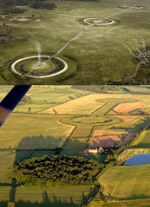
We now continue with the 3-part triple monument Ring of Brodgar, Ness of Brodgar and the Stones of Stennes and the nearby Orkney Neolithic settlement of Skara Brae and the burial mound Maeshowe.
The 3-part triple monument Ring of Brodgar, Ness of Brodgar and the Stones of Stennes is therefore an extended version of the Thornborough triple Henges, in all my presentations I first talked about the relatively simple Thornborough triple Henges and only then about the more complex 3-part triple monument Ring of Brodgar, Ness of Brodgar and the Standing Stones of Stennes.
As an introduction, a beautiful sentence from the UNESCO, in granting the World Heritage status for the various monuments on the Orkney Islands:
-
The monuments in the heart of Neolithic Orkney proclaim the triumphs of the human spirit in early times and in isolated places.
They were roughly contemporaneous with the mastabas of the archaic period of Egypt (first and second dynasties), the brick temples of Sumeria, and the first cities of the Harappan culture in India, and a century or two earlier than the Golden Age of China.
Unusually beautiful for their early date, and with a remarkably rich preservation of evidence, these sites stand as a visible symbol of the achievements of early peoples outside the traditional centers of civilization
In addition to the above description, in 1981 someone wrote the following special text about the 3-part triple monument Ring of Brodgar, Ness of Brodgar and the Standing Stones of Stennes, which has always intrigued me:
-
Imagine then that families approach Stenness at the appointed time of the year, men, women, and children, with bundles of bones collected from the skeletons of exhumed corpses - skulls, jaws, long bones - that also bear the skulls of totem animals, herding a beast that was one of many slaughtered for the feast that would accompany the ceremonies.
In my explanation I have always used the above excellent description from 1981, mixed with my own contribution:
-
From the Neolithic settlement of Skara Brea people walked along a ceremonial road (Avenue) to the Standing Stones of Stennes, according to late-medieval sources dedicated to the Moon. All kinds of initial rituals took place there.
Then they walked to the Ness of Brodgar Temple Complex, where, among other rituals, the sacrificial animals brought with them were sacrificed. Of course, a visit was also made to the NEOLITHIC CATHEDRAL (Structure 10).
And then on the way to the Ring of Brodgar, according to late medieval sources dedicated to the Sun, for the closing rituals. Especially close to the Ring of Brodgar, many Neolithic monuments and burial mounds are found, culminating in the large tomb Maeshowe.
But also this:
-
If you want to know more about these Orkney monuments, and especially about the most intriguing monument for me, the NESS OF BRODGAR, search the internet with the keyword NESS OF BRODGAR combined with one of the names below.
If you want to search YouTube for just one of the names below, you can watch hours of videos, which I have done once!
Alice Roberts
Alice Roberts is a paleopathologist, writer and BBC television presenter of one of my favourite BBC programmes Digging for Britain. It will be broadcast from 2010 and I am already watching, I estimate from 2012!
The Digging for Britain series focuses on archaeological excavations and research in the UK, both at new sites and at sites that are already well known, including the Ness of Brodgar at one time.
Since 2012, Alice Roberts has also been a Professor at the University of Birmingham, so she is always announced by the BBC as Professor Alice Roberts, fine, she deserves it! Learned so much from her. Also remember Alice Roberts with her series about Egypt and Pompeii and her train journey through the Ottoman Empire. GREAT!
Alice Roberts has also talked about Stonehenge several times, the last time (?) was about the location of the Stonehenge Bluestones in Waun Mawn, we will also come back to that!
-
Alice Roberts is always rightly enthusiastic about special finds and conclusions, such as this one about Avebury (on this web page we already have a lot about Avebury, which can be found with CTRL-F)
Spring 2026 the series Digging for Britain from 2017 repeated with 2 special finds and conclusions:
Two presented Long Barrows were first built and used as a kind of home. After a certain period of time, the house was (deliberately?) burned and only then was the whole thing used as a tomb.
During excavations in Avebury the following result was presented:
In the Avebury stone circle, the largest in Europe, also lived people, only much later would the Avebury stone circle be used for ceremonies! During the period that people lived in the huge Avebury stone circle, a central "dwelling" with Obelix was even built surrounded by a square stone circle, as it was called in the broadcast. These are the conclusions drawn from excavations.
That there was a square stone circle with "dwelling" and Obelix in Avebury was a big surprise. I immediately started looking but could hardly find anything about it. Alice Roberts rightly speculated in 2017 that more of these square stone circles with "dwelling" and Obelix would be discovered in stone circles in the future, never heard anything about it again.
- My other favorite BBC program that I've been following every time since 2005 (?) is the Antiques Road Show on Sunday evening.
Nick Card
Since 2004, Nick Card has been leading the excavations in the Ness of Brodgar.
Started with small-scale test trenches, In the years that followed, it became large-scale excavations.
Nick Card gives many lectures and interviews about the excavations in the Ness of Brodgar.
When Nick Card is announced in a BBC broadcast, it is almost always about the Ness of Brodgar!
Neil Oliver
Neil Oliver is a Scottish archaeologist and was also once a BBC presenter of historical series, unfortunately Neil has stopped doing that.
Neil Oliver was chairman of the National Trust for Scotland from 2017 to 2020.
Neil Oliver I remember, they are undoubtedly all on YouTube, from the BBC series Coast, Vikings and A History of Scotland.
Neil Oliver once presented the BBC series The Celts: Blood, Iron and Sacrifice together with Alice Roberts. The Battle of Bannockburn, which is important for Scotland, was also investigated by Neil Oliver in a BBC program, complete with archaeological excavations.
In 2017 (?) Neil Oliver presented an unforgettable series about the Ness of Brodgar, complete with 3D animations. The screenshots I made of them are also used on this web page and you can also find them on the internet, more people came up with the screenshots idea of course. In corona times, the series about the Ness of Brodgar with presenter Neil Oliver was repeated, I assume it can be found on YouTube.
Neil Oliver has also mentioned Stonehenge several times.
Across the Orkney Islands, Neil Oliver, along with other presenters, has presented the BBC series Britain's Ancient Capital: Secrets of Orkney, which can still be found via a BBC webpage. The series was excellent!
- Really finally, I'm also a big fan of the historical BBC programs presented by Lucy Worsley.
The Standing Stones of Stennes and the Ring of Brodgar
Stennes is Old Norse for stone cape (Stone Headland), Brodgar is Old Norse for bridge cape (Bridge Headland), all references to the strip of land that connects the Brodgar cape and Stenness cape. In the composite image below, it is also explained below the composite image.
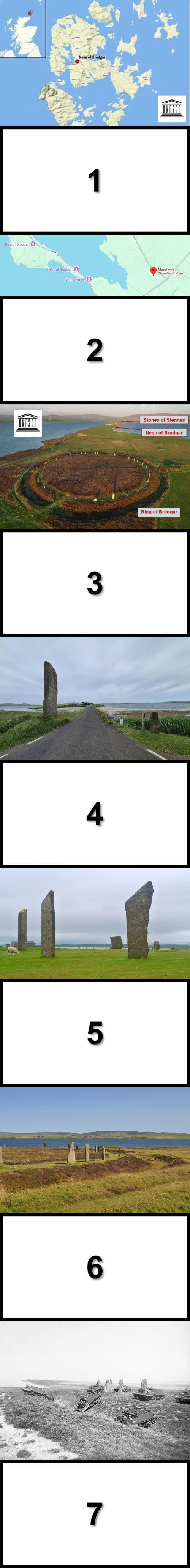
Explanation of image 1 of the above composite images
Very coarse Ness of Brodgar location, if you zoom out it turns out to be the location of Maeshowe! But in itself the map is of course correct, because all other sites (from Skara Brae to Stennes) are nearby.
Explanation image 2 of the above composite images
Unfortunately a bit vague Google Maps.....
The right pennant / right pin is the location of Maeshowe.
Left from bottom to top, the location of the Watch Stone just north of the Standing Stones of Stennes (Standing Stones of Stennes does not have its own pin), to the top the location of the Ness of Brodgar, above that the location of the Ring of Brodgar.
Hopefully the connecting bridge can be discovered just above the Watch Stone!
This connecting bridge connects Stennes in the south with Brodgar in the north, in the Mesolithic it is assumed that no connecting bridge was needed. Until the construction of the connecting bridge there were stepping stones, once read.
Skara Brae is located more to the North-West, about 2 hours walk, from the Ness of Brodgar. From the Ness of Brodgar to Maeshowe it is a 30-minute walk.
Explanation image 3 of the above composite images
The overview of the triple monument Ring of Brodgar, Ness of Brodgar and the Stones of Stennes, which I always showed in my Stonehenge presentations.
All three monuments within walking distance!
Explanation image 4 of the above composite images
The Watch Stone of the Stones of Stennes is located outside the Stones of Stennes stone circle and is 5.6 m high.
The Watch Stone is located at the connecting bridge, on the other side the Ness of Brodgar.
Once there was also a second Watch Stone, probably stood on the other side of the connecting bridge.
All stones of both the Stones of Stennes and the Ring of Brodgar are flat stones, called SLABS.
From chapter 9. When did stone circles, such as those of Stonehenge, with or without a henge (to be found via the index of this web page) the following selection of various stone circles including a number of slab stone circles:
The stones of the stone circles of Stonehenge, Stanton Drew and Avebury are therefore very special stones, slabs are possibly "easier" to work with stones?
Explanation image 5 of the above composite images
We will start with a quote from chapter 1 of this web page How to pronounce Stonehenge:
-
The emphasis should be on the 2e syllable and therefore NOT on the 1e syllable:
So it is Stone HENGE and not STONE Henge.
So it is Sten NES and not STEN nes.
On image 5 the Standing Stones of Stennes, probably the oldest stone circle in the UK and possibly also in Western Europe, founded around 3100BC, probably by Nordic peoples. The Stonehenge stone circle was founded from around 2500BC.
The Standing Stones of Stennes once stood in the middle of a real henge, so with a rampart and moat. The moat / ditch was carved in stone to a depth of 2 meters and was 7 meters wide in some places. Animal bones were also found in this moat, probably as a ritual sacrifice.
The Standing Stones of Stennes were built up with about 5 meter high slabs of about 30 cm thick with angular tops. Originally, there were 12 slabs that were placed together in an ellipse shape.
Until well into the 18th century, the Standing Stones of Stennes were still surrounded by Nordic traditions and rituals.
The Odin stone, named after the Norse God Odin, has become famous. The Odin stone stood in the north of the henge and was pierced with a round hole, large enough to put a hand through from either side and then hold hands, which was done during all kinds of rituals, such as weddings. The tradition was named the Vow of Odin.
At the beginning of the 19th century, the now disappeared slabs, including the Odin stone, were destroyed by a local landowner, he no longer wanted people to walk on his land. After protests, the other slabs remained. At the beginning of the 20th century, the stone circle was restored as well as possible.
In addition this repetition from the introduction:
In 1981 someone wrote the following special text about the 3-part triple monument Ring of Brodgar, Ness of Brodgar and the Standing Stones of Stennes, which has always intrigued me:
-
Imagine, then, that at the appointed time of year, families approach Stenness, men, women, and children, with bundles of bones collected from the skeletons of exhumed corpses-skulls, jaws, long bones-also carrying the skulls of totem animals, herding a beast that was one of many slaughtered for the feast that would accompany the ceremonies.
In my explanation I have always used the above excellent description from 1981, mixed with my own contribution:
-
From the Neolithic settlement of Skara Brea we walked along a ceremonial road (Avenue) to the Standing Stones of Stennes, according to late-medieval sources dedicated to the Moon. All kinds of initial rituals took place there.
Then we walked to the Ness of Brodgar Temple Complex, where, among other rituals, the sacrificial animals were sacrificed. Of course, a visit was also made to the NEOLITHIC CATHEDRAL (Structure 10).
And then on the way to the Ring of Brodgar, according to late medieval sources dedicated to the Sun, for the closing rituals. Especially close to the Ring of Brodgar, many Neolithic monuments and burial mounds are found, culminating in the large tomb Maeshowe.
Notes Figure 6 and 7 of the above composite images
We'll start with the last sentence of explanation 5 of the above composite images, a few lines up from where you are now......
-
And then on our way to the Ring of Brodgar, according to late medieval sources dedicated to the Sun, for the closing rituals. Especially close to the Ring of Brodgar, many Neolithic monuments and burial mounds are found, culminating in the large tomb Maeshowe.
The construction of the Ring of Brodgar started around 2200BC, so after the start of Stonehenge in 2500BC.
Nordic peoples even applied runic engravings to the slabs from the 9th century onwards, apparently the Ring of Brodgar was still used for rituals at that time.
But people came to this place as early as 6000BC, so it has attracted people for at least 7000 years!
The about 5 meter high slabs are in a perfectly aligned circle with a diameter of 104 meters. In terms of diameter, the third British stone circle, after Avebury, diameter over 300 meters and Stanton Drew, diameter about 112 meters (see chapter 8 of this web page). The highest slabs are in the west and south, including the Comet Stone in the southeast.
Originally there were 60 slabs, of which 27 are now left. The ditch has a diameter of 380 meters, and is made of solid stone, up to 3 meters depth with a width of 9 meters, what a job that must have been!
In principle, the inner circle of the Ring of Brodgar is not accessible, the soil there is too vulnerable in terms of nature. Apparently this was not taken into account in 1941, or they did not know it at the time?? British tanks then drove straight through the Ring of Brodgar (see image 7 of the composite images above) on exercise on the deserted Orkney Islands, which I have always found strange, all those tanks had to be sailed over a distance of 15 km by ship, including crews and supplies, could it really not have been otherwise?
THE NESS OF BRODGAR
For me the most fascinating part of the Triple Monument Ring of Brodgar, Ness of Brodgar and the Stones of Stennes
We're not going to talk about all 41 excavated "buildings", called structures. Structure 1 was discovered in 2003, after which it was renumbered to structure 41 in 2024. Because we concentrate on structure 10, the famous NEOLITHIC CATHEDRAL. Structure 10 is also the largest excavated building on the Ness of Brodgar, about 25 meters long, 20 meters wide, with walls 4 meters thick.
Not all structures were built or put into use at the same time. Some structures are built over collapsed structures, the foundations of the collapsed structures were not always in order. Over a period of more than 1000 years (from about 3300BC to about 2300BC) demolition and rebuilding took place, sometimes over several collapsed structures. The start of the Ness of Brodgar complex has therefore started earlier than the Stones of Stennes, Ring of Brodgar, Stonehenge, Avebury and many more famous monuments.
Structure 10, the NEOLITHIC CATHEDRAL, was built around 2900BC also on top of the remains of earlier buildings, such as Structure 20. Around 2400BC, structure 10, the NEOLITHIC CATHEDRAL was decommissioned. This probably marked the end of the entire Ness of Brodgar as an important center. After the ceremonial closure of structure 10, the NEOLITHIC CATHEDRAL, (we will come back to that) structure 10, the NEOLITHIC CATHEDRAL, was largely demolished and covered with a huge mountain of garbage and earth, leaving it as a monumental hill in the landscape.
How was it discovered around 2003 that something special could be found in the meadows of the Ness of Brodgar?
I always first tell the story about Xi'an China, made famous for the Terracotta army. In China, a European tour guide has a higher status, I have always had the impression. So on one of the trips I carried out, I was invited by the accompanying local Chinese guide if I would like to meet the discoverer of the Terracotta army, of course! So I was allowed to shake hands with the farmer who was digging a well one day and then suddenly a Terracotta warrior head appeared, a familiar story, but he told it enthusiastically just as if it had happened yesterday, GREAT, what a memory!
In 2003, while ploughing a piece of meadow for the construction of a flower garden, a lid of a Mesolithic coffin was discovered in the unspoilt meadows of the Ness of Brodgar. Upon further investigation, more and more was discovered, of course. Of course, no one expected that 41 structures would eventually be discovered by 2024.
A very nice summary can be found on the homepage of the Ness of Brodgar website:
-
From 2004, 20 years of excavation on the Ness of Brodgar brought to light a huge complex of monumental Neolithic buildings from the centuries around 3000 BC.
Nowhere in Europe are three hectares of such spectacular structures to be found. .
This makes the Ness of Brodgar site one of the most important archaeological sites in the world today, changed our understanding of Neolithic Orkney and shed new light on the prehistory of northern Europe.
The fieldwork ended in 2024 and the focus is now on the analysis of the data collected after the excavation. This will lead to full publication with much more online availability.
In 1981 someone wrote the following special text about the 3-part triple monument Ring of Brodgar, Ness of Brodgar and the Standing Stones of Stennes, which has always intrigued me:
- Imagine, then, that families approach Stenness at the appointed time of year, men, women, and children, with bundles of bones collected from the skeletons of exhumed corpses-skulls, jaws, long bones-that also bear the skulls of totem animals, herding a beast that was one of many slaughtered for the feast that would accompany the ceremonies.
In my explanation I have always used the above excellent description from 1981, mixed with my own contribution:
-
From the Neolithic settlement of Skara Brea we walked along a ceremonial road (Avenue) to the Standing Stones of Stennes, according to late-medieval sources dedicated to the Moon. All kinds of initial rituals took place there.
Then we walked to the Ness of Brodgar Temple Complex, where, among other rituals, the sacrificial animals brought with them were sacrificed. Of course, a visit was also made to the NEOLITHIC CATHEDRAL (Structure 10).
And then on our way to the Ring of Brodgar, according to late medieval sources dedicated to the Sun, for the closing rituals. Especially close to the Ring of Brodgar, many Neolithic monuments and burial mounds are found, culminating in the large tomb Maeshowe.
And of course this: On the digitized image the TEMPLE COMPLEX of the Ness of Brodgar:
- Actually, the name NEOLITHIC CATHEDRAL refers to the 10th excavation at the Ness of Brodgar site ( Structure 10, we'll come back to it), but you see more and more the name NEOLITHIC CATHEDRAL used for the entire Ness of Brodgar site!

To summarize a very long story about the Ness of Brodgar, we will limit ourselves to the highlights using the composite image above.
Explanation image 1 of the above composite images
Around 2014 (?) the BBC came out with a series of documentaries about the Ness of Brodgar with Neil Oliver as presenter, a small biography of Neil Oliver can also be found on this web page, for example via CTRL-F.
For me the first acquaintance with the Ness of Brodgar excavations, I had read something about it of course, but the dimensions of the Ness of Brodgar complex were also a total surprise for me!
With the help of geothermal (?) measurements a large number of structures were found. Even then, the cautious conclusion was that the structures could never have been built for habitation, it could have been a, in short, a temple complex, the other options soon fell by the wayside in the course of the excavations. In image 2 it was very clearly explained with the help of a 3D animation how the Ness of Brodgar complex was constructed.
Only much later did I notice the dark part on image 1, so it turned out to be structure 10, the NEOLITHIC CATHEDRAL!
To the left is in the direction of the Standing Stones of Stennes, to the bottom right is in the direction of the Ring of Brodgar. However, if you compare this image 1 with image 3, the conclusion must be that image 1 is not correct in terms of north-south direction. Figure 1 was probably created with the help of a computer program. The black stripe at the top of image 1 is also not the current road that is there now, as the current road is at the bottom. So I have always told you that this image 1 shows the situation as it could have been around 2500BC. Is that true?
Explanation image 2 of the above composite images
With the help of a 3D animation it was explained how the Ness of Brodgar complex was created and constructed.
BEAUTIFULLY DONE.
Neil Oliver walked onto the terrain (Neil Oliver can be found in the red circle at the bottom) and suddenly all kinds of structures came up and disappeared to make way for other structures. With, of course, the story that structures were replaced by other structures, sometimes as an addition, sometimes on top of old structures that had sometimes collapsed. And indeed, at a certain point a wall came up, which did not disappear.
This beautiful 3D animation, image 2 is just a snapshot, has always stayed with me.
The wall around the Ness of Brodgar temple complex was soon named Great Wall of Brodgar and turned out to be at least 4 meters high and 4 meters wide, Total length about 100 meters. The purpose of the Great Wall of Brodgar must have been a more than visual shielding of the Ness of Brodgar temple complex. This wall, the Great Wall of Brodgar, with this function was, in my opinion, a complete surprise for everyone.
I have never been able to find this BBC episode with those beautiful 3D animations. So HELP!
Based on image 2 the following beautiful image was created, here too I think the North-South direction is wrong. The processions always came, it is generally assumed, from the Stones of Stennes (bottom left) and then somewhere to the left inside the Ness of Brodgar temple complex the NEOLITHIC CATHEDRAL (Structure 10) must be found. But where?? But maybe I should analyze the next image again?
Finally, in summary of the most important general concluding remarks about the Ness of Brodgar excavations, we will then continue with structure 10, the NEOLITHIC CATHEDRAL.
The Ness of Brodgar excavations were completely covered again in August 2024 to allow for future excavations. Without a cover, the excavated Ness of Brodgar would be severely affected or even disappear due to the sometimes harsh weather conditions on the Orkney Islands.
During the construction of the Ness of Brodgar, the Neolithic designers have already built a drainage system that is still working.
The fieldwork ended in 2024 and the focus is now on the analysis of the data collected after the excavation. This will lead to full publication with much more online availability. For example, about 600 decorated stones have been found, all have yet to be described.
July 2026, the Ness of Brodgar was investigated for the last (?) time with ground-penetrating radar (GPR). Because it is estimated that only about 10% of the Ness of Brodgar has been studied so far.
The Ness of Brodgar has been used for over 1200 years, from about 3400BC to 2200BC. So translated to our time, from Charlemagne (800) to the year 2000. UNBELIEVABLE
Explanation of figures 3 and 4 of the above composite images
The black rectangle in figure 4 is structure 10, the NEOLITHIC CATHEDRAL, shown in Figure 3 in Trench P: the dark red rectangle on the right is structure 10.
Explanation of figures 5, 6 and 7 of the above composite images
In the general section on the Ness of Bodgar we wrote:
-
Structure 10, The NEOLITHIC CATHEDRAL, was built around 2900BC also on top of the remains of earlier buildings, such as structure 20. Around 2400BC, structure 10, the NEOLITHIC CATHEDRAL was decommissioned. This probably marked the end of the entire Ness of Brodgar as an important center. After the ceremonial closure of structure 10, the NEOLITHIC CATHEDRAL, (we will come back to that) structure 10, the NEOLITHIC CATHEDRAL, was largely demolished and covered with a huge mountain of garbage and earth, leaving it as a monumental hill in the landscape.
Structure 10, the NEOLITHIC CATHEDRAL, appears to have been closed during a final one-time ceremonial closure, during which more than 400 bovine were sacrificed, The meat was distributed among those present who probably ate it on the spot, so it was a bit expensive, so it was an important event!
The remaining beef bones were collected and placed around structure 10, on top of which boned carcasses of red deer were placed. The whole was covered by one or more inverted cattle skulls. Afterwards, the NEOLITHIC CATHEDRAL was allowed to collapse!
The Ness of Brodgar was thus closed and abandoned and disappeared in the course of the following centuries!
Of course also a number of selected facts about structure 10, the NEOLITHIC CATHEDRAL:
Dimensions: about 25 meters long and 20 meters wide, with outer walls 4 meters thick. The NEOLITHIC CATHEDRAL is the largest excavated building on the Ness of Brodgar with this size!
Including a central room of 8 by 8 meters with rounded corners, the walls were decorated with decorated stones.
Later, the eight square meter interior space was converted into a cruciform layout, similar to and in the direction of the Maeshowe tomb, the huge roof was tiled with stone tiles (see image 7).
The NEOLITHIC CATHEDRAL was also completely rebuilt after collapse, in short, it was a very important building!
Around the NEOLITHIC CATHEDRAL even a 1 meter wide path was built, where a number of buttresses were placed.
In short, the NEOLITHIC CATHEDRAL, had to IMPOSE both internally and externally .
Finally: on the west side of the interior space was a hole (image 6) that is compared to the Odin stone of the Stones of Stennes.
Quote from the Standing Stones of Stennes story:
-
Until well into the 18th century, the Standing Stones of Stennes were still surrounded by Nordic traditions and rituals.
The Odin stone has become famous, named after the Norse God Odin. The Odin stone stood in the north of the henge and was pierced with a round hole, large enough to put a hand through from either side and then hold hands, which was done during all kinds of rituals, such as weddings. The tradition was named the Vow of Odin.
At the beginning of the 19th century, the now disappeared slabs, including the Odin stone, were destroyed by a local landowner, he no longer wanted people to walk on his land. After protests, the other slabs remained. At the beginning of the 20th century, the stone circle was restored as well as possible.
An example of a colored stone found in the NEOLITHIC CATHEDRAL, very special!
Total are, distributed over the site of the Ness of Brodgar, even more than 600 decorated stones found .
Really unique is the discovery of red, as shown in image 8, yellow and black pigments on the walls of especially (?) the NEOLITHIC CATHEDRAL, the earliest evidence of painted Neolithic buildings in the UK.
Also, more than 40,000 shards of Grooved Ware, polished stone axes, and rare carved stone balls have been found scattered throughout the site of the Ness of Brodgar.
Note Figure 9 (Venus of Orkney) and 10 (Brodgar Boy) of the above composite images
MEA CULPA
ALWAYS TOLD that Alice Roberts (via CTRL-F you can find more about her on this webpage) during a Digging for Britain film shoot on the site of the Ness of Brodgar, the Venus of Orkney was allowed to hold, found on the site of the Ness of Brodgar, I thought.
I always said that it could also have been the Brodgar Boy, but Alice Roberts had something completely different from the Brodgar Boy in her hands, according to my memory. What did Alice Roberts have in her hands, in retrospect?
In my notes there was also CHECK and I only did that a few weeks ago!
It turns out:
The Venus of Orkney, just 4 cm tall, also known as the Westray Wife, is a 5000-year-old Neolithic sandstone figurine that was discovered in 2009 on the island of Westray in Orkney, Scotland. It is the earliest representation of a human form ever found in Scotland and contains the oldest depicted face in the UK.
The Venus of Orkney has a round head with distinct eyebrows, eyes, and a nose. The body is diamond-shaped with notches that may represent breasts or garments. Although it is called the Venus or Orkney, it is unclear whether it was a fertility symbol, a deity, or simply a children's toy.
Once I went with a group in the National Museum of Scotland in Edinburgh looking for the Venus of Orkney, couldn't find it, afterwards of course, but then I thought, too little time and an attendant was nowhere to be found. Now understand that the Venus of Orkney can be found in the
-
Located in the heart of Pierowall Village, Westray Heritage Centre is a Full Museum Accreditation holder. Explore the island's history, archaeology, and genealogy through fascinating displays and exhibits, including the world-renowned Westray Wife (Venus of Orkney) and Westray Stone.
Explore our most significant exhibits, including the Westray Wife (Venus of Orkney) and Westray Stone - treasures of international significance.
Although the Brodgar Boy is often referred to as a statuette, it may also have been a pendant or part of a larger clay object based on its tapered shape. Although the Brodgar Boy does have a recognizable head, a body and two eyes.
Finally, we are also going to talk about the nearby Neolithic settlement Skara Brae, probably the builders of the 3-part monument Ring of Brodgar, Ness of Brodgar and the Stones of Stennes and possibly also of the burial mound Maeshowe, and so Maeshowe is also discussed in conclusion, including the comparison with the Irish burial mound Newgrange.
At both the Maeshowe mound and the Irish Newgrange mound, only light enters during the winter solstice!
Finally, the comparison with Stonehenge

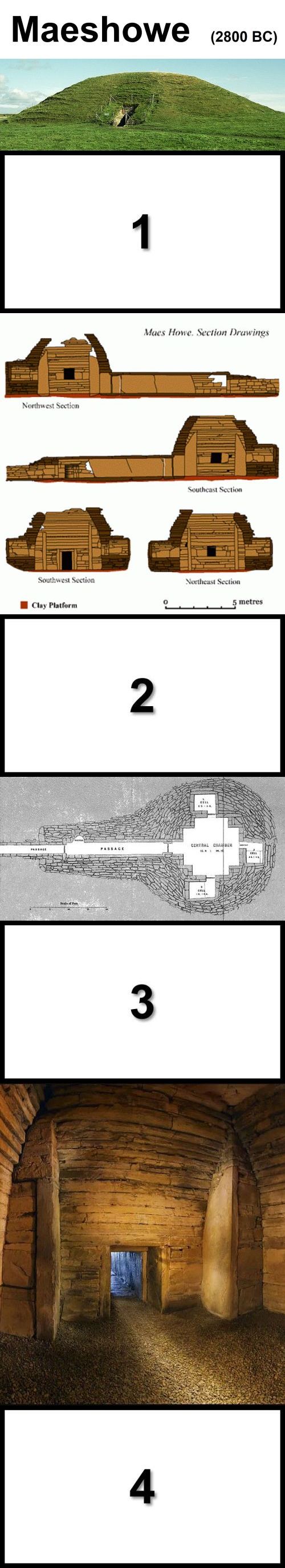
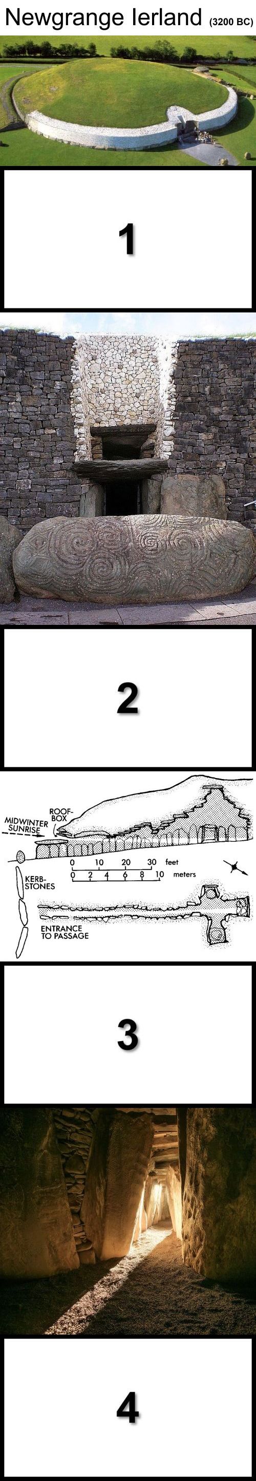
Omschrijving
| Back to the INDEX |
|---|
23. Titel
-
Omschrijving
| Back to the INDEX |
|---|
24. Titel
-
Omschrijving
| Back to the INDEX |
|---|
25. Titel
-
Omschrijving
| Back to the INDEX |
|---|
26. Titel
-
Omschrijving
| Back to the INDEX |
|---|
27. Titel
-
Omschrijving
| Back to the INDEX |
|---|
28. Titel
-
Omschrijving
| Back to the INDEX |
|---|
29. Titel
-
Omschrijving
| Back to the INDEX |
|---|
30. Titel
-
Omschrijving
| Back to the INDEX |
|---|
wordt vervolgd
Klik maar even hier
bla bla bla bla
Aan dit verhaal wordt nog gewerkt